
Broadmead Neighbourhood Design Code consultation
The Broadmead Neighbourhood Design Code Supplementary Planning Document (SPD) is intended to steer the transformation of Broadmead into a high quality, liveable urban neighbourhood. The guidance sets out design principles and best practice examples to embed high quality design into redevelopment of the area.
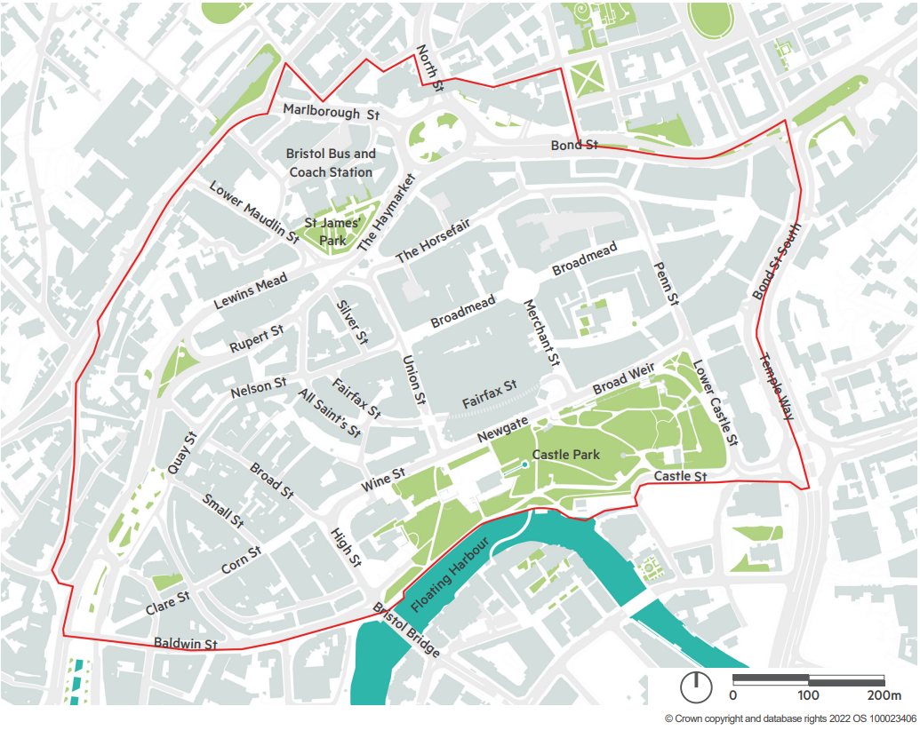
The SPD provides guidance to support interpretation and implementation of Bristol’s Local Plan, specifically Policy DS1: Bristol City Centre. The SPD applies to the area of the city centre covered by the Broadmead, Castle Park and the Old City area shown in the map below. This is the same boundary as used in the Bristol City Centre Development and Delivery Plan.
Area in which the Broadmead Neighbourhood Design Code SPD applies
The SPD is intended to be used by all professionals involved in the planning, design and delivery of new buildings and spaces within Broadmead. This particularly extends to architects, landscape architects, urban designers, planners, engineers, developers, landowners and planning officers. The SPD can also be used by local people keen to advocate for design quality in Broadmead and the city centre.
In this consultation, we ask you for your views on the draft Broadmead Neighbourhood Design Code SPD, before a final version is adopted.
Consultation
The survey summarises the design priorities and design principles in the SPD and asks for your views on these. You can pdf read the SPD(17.10 MB) in full and comment on any aspect of the document as part of your response in this survey.
If you would like to read more about consultation that has already taken placeduring drafting of the SPD, or read about equality considerations, you can follow the links below:
We have provided a glossary of terms in the further information section below.
We would like your feedback on the draft SPD before a final version is adopted.
We want views from as many people and organisations as possible. Bristol residents, individuals who work in the city or visit for shopping, education or leisure, businesses, community groups, transport organisations, as well as architects, landscape architects, urban designers, planners, engineers, developers, landowners and planning officers - anyone who has an interest in the future design of Bristol city centre.
Closed for feedback
Ended: 27 January 2025
What happens next
All responses to this consultation will be analysed. The feedback will be used to help develop an updated version of the Broadmead Neighbourhood Design Code SPD.
A decision on whether to approve the updated SPD will be made by Bristol City Council’s Economy and Skills Policy Committee in spring 2025. In making their decision, the committee will consider the report of consultation responses.
If the SPD is approved, it will become a ‘material consideration’ meaning the council will have to refer to it when deciding on planning applications or commenting on regeneration proposals.
Further information
What is this document?
The Broadmead Neighbourhood Design Code SPD is a proposed new Supplementary Planning Document (SPD) providing guidance to support interpretation and implementation of Bristol’s Local Plan, specifically Policy DS1: Bristol City Centre.
The Broadmead Neighbourhood Design Code SPD has been prepared to shape and steer the transformation of Broadmead into a high quality, liveable urban neighbourhood. The guidance is concerned with embedding the fundamentals of high quality design into Broadmead, using principles and best practice examples to do so.
The SPD is structured by scale, covering design fundamentals at the neighbourhood, streets and spaces, building and home scale, and sets out fundamental design principles. These fundamentals are design considerations critical to take account of from the project inception.
Why does Bristol need a Broadmead Neighbourhood Design Code SPD?
The Broadmead Neighbourhood Design Code SPD has been prepared to shape and steer the transformation of Broadmead into a high quality, liveable urban neighbourhood. The guidance is concerned with embedding the fundamentals of high quality design into Broadmead, using principles and best practice examples to do so.
The City Centre Development and Delivery Plan (the DDP), endorsed in 2023, provides a transformational vision and strategy for how the Bristol city centre should evolve in the coming years. Its purpose is to guide and influence future development and infrastructure projects that come forward within the Broadmead area and is a material planning consideration in the determination of planning applications. A key objective from the DDP to create more detailed design guidance for new development. This proposed SPD is being prepared to meet that objective.
What is an SPD?
A Supplementary Planning Document (SPD) build upon and provide more detailed advice or guidance on policies in an adopted local plan. As they do not form part of the development plan, they cannot introduce new planning policies into the development plan. They are however a material consideration in decision-making.
What is a Design Code?
A design code is a set of design requirements for the physical development of a site or area. It is made up of rules that are clear, specific and unambiguous, and it should normally include extensive graphical illustrations. The code should build upon a design vision, such as a masterplan or other design and development framework for a site or area. In this case, this is the Bristol City Centre Development and Delivery Plan (2023).
Who should use the SPD?
The SPD is intended to be used to be used by all professionals involved in the planning, design and delivery of new buildings and spaces within Broadmead. This particularly extends to architects, landscape architects, urban designers, planners, engineers, developers, landowners and planning officers. The SPD can also be used by local people keen to advocate for design quality and in Broadmead and the city centre.
Where does the SPD apply?
The SPD is applicable to the area of the city centre covered by the Broadmead, Castle Park and the Old City area within the Local Plan (Publication Version, November 2023) Policy DS1. This is the same boundary as used in the Bristol City Centre Development and Delivery Plan 2023). Both documents set out the need for all development to accord with design guides, codes, frameworks and strategies, i.e. this SPD.
What is the City Centre Development and Delivery Plan (the DDP)?
The Bristol City Centre Development and Delivery Plan (DDP) provides a transformational vision and strategy for how the Bristol city centre should evolve in the coming years, ensure it is an inclusive, sustainable and a reconnected place for everybody.
The DDP looks at how we can ensure the city centre is a place of diverse retail, vibrant cultural facilities, and a thriving evening economy, while at the same time the city centre is somewhere that local people can call home. The plan sets out how the vision can be realised through the consideration of six thematic strategies:
- Destination and identity
- Community and culture
- Movement and connections
- Public realm and open space
- Green infrastructure and nature
- Land use and development
The DDP was created between 2021 to 2023, building from the adopted City Centre Framework, July 2020. The plan went out for consultation in the Summer of 2023 and was endorsed by Bristol City Council’s Cabinet in December 2023. The document is a ‘material consideration’ for assessing planning applications, as well as Bristol City Council investment decisions in the area.
It is set out in two parts, which can be found on supplementary planning documents practice notes and other planning guidance.
How does the SPD relate to Planning Policy?
The National Planning Policy Framework (NPPF, 2023) sets out the government’s planning policies for England and how these are expected to be applied. The NPPF provides an overarching framework for the development of planning policies and planning decisions. NPPF paragraph 134 is clear design guidance should be set out in Supplementary Planning Documents in order to carry sufficient material weight. Paragraph 139 states that development that is not well-designed should be refused, especially where it fails to take account of supplementary planning documents such as design guides.
The Local Plan 2023 further emphasises this requirement through Policy DS1; setting out the need for all development to accord with design guides and codes.
How this draft SPD has been created
The draft SPD has been built upon the vast research and engagement activities undertaken as part of creation of the City Centre Delivery and Development Plan, endorsed in December 2023. It builds from emerging Local Plan Polices, which have been subject to wider stakeholder input.
The Council have engaged with a number of key stakeholders are part of the preparatory process of the draft document, but this consultation is key in shaping and informing the SPD to ensure it is fit for purpose.
Who to ask about the SPD
You can ask questions and give us your feedback about the SPD through the survey, so we can capture and respond to these as part of the development of the document.
If you have any questions or issues with the survey, email CityCentreRegeneration@bristol.gov.uk
Glossary of terms used in the SPD
Active frontage
The external face of a building that fronts onto a street or open space and is characterised by entrances, windows and other openings that create interest and activity, especially at ground floor.
Boundary treatment
The physical interface that delineates the public street from the private building, crossing this before reaching the building entrance. Often associated with residential buildings, treatments can include planting, low fences or walls.
Building height to street width ratio
The proportional relationship between building heights and street width, having a direct bearing on the sense of enclosure.
Cityscape
The visual appreciation of an urban area as observed from long range views, informed by the combination of and relationship between its physical components and attributes e.g. the diversity of the city silhouette from a long range view.
Datum
The prevailing building height of an urban block which serves to unify different building typologies and architectural styles through this shared and defining characteristic.
Desire line
A route that represents the shortest or most easily navigated route between an origin and destination, highly desirable for its convenience.
Doorstep play
A landscaped space including engaging play features for young children under 5 that are close to their homes, and places for carers to sit and talk.
Dual aspect
A home with openable windows on two or more walls which may be either on opposite sides of a dwelling or on adjacent sides when wrapping around a corner.
Elevation
An exterior wall of a building, typically facing north, south, east or west.
Enclosure
The extent to which streets and open spaces are visually defined by buildings, walls and trees. A continuous perimeter of these components between public and private space can achieve enclosure.
Facade
The design components comprising an elevation e.g. windows, materials, details.
Fenestration
The arrangement and design of entrances, windows, balconies and other openings on a building facade. A well composed fenestration can achieve well balanced proportions and help reduce visual bulk.
Green and blue infrastructure
Natural features incorporated into the landscape and public realm design to boost access to nature and climate resilience e.g. street trees for urban shading and rain gardens for storm water management.
Human scale
The proportion of building or public realm space in relation to human dimensions.
Legibility
The combination of buildings, streets, trees and open spaces that use visual cues to create an intuitive and easily navigable environment.
Managed use
A cooperative approach between residents, freeholders and management companies on the fire safety of shared corridors, staircases and lobbies that permits selected fire resistant items in circulation spaces e.g. plant pots, door mats, framed pictures. This can encourage a sense of home, personality and responsibility for shared spaces but must be approved in a fire risk assessment and continuously monitored.
Massing
The three dimensional volume and structure of a building. Massing is expressed through the size, shape and scale of its different components. Commonly understood as the expression of a building without any finer architectural elements and details.
Meanwhile activation
Short-term use of temporarily empty buildings or public realm, often during redevelopment. Meanwhile uses can take a potential problem and turn it into an opportunity, by testing possible long-term uses.
Modal
Concerning the use of types of transport. A modal strategy might include limiting the types of vehicle allowed to enter a street during a time of day.
Natural surveillance
The placement of physical features, activities and people in such a way as to maximise visibility and foster positive social interaction.
Orthogonal
Concerning buildings designed using 90 degree right angles.
Pastiche
Buildings designed to directly imitate architectural styles associated with historical periods.
Perimeter block
Buildings arranged along the edge of an urban block, using their physical mass to define the outer (and public) edge of the block, forming a boundary between public and private space. The blocks themselves have limited permeability but are set within a highly permeable street network.
Permeability
A connected street or pedestrian network with a high frequency of routes that allow easy passage of movement, often associated with a fine urban grain.
Scale
Most commonly understood as building height, though scale is relative to another (usually neighbouring) building’s height. It can also relate to the size of a building’s different elements e.g. massing, fenestration, rather than purely its absolute building height.
Semi-private space
Shared communal space with plots intended for access and use by residents of the buildings, forming a street, garden or courtyard.
Serial vision
The way a neighbourhood or part of the city is experienced, referring to the unfolding perspectives and sequential views experienced as you move through space. For instance, as a street turns and a view towards a green space or building opens up.
Single aspect
A home with openable windows on only one wall, resulting in only one ‘view’ outside and often issues with air flow owing to lack of cross-ventilation.
Set Back
A step-like recess in massing of upper storeys, often used where proposed building heights exceed prevailing building height datum of a street. This strategy can preserve the established building height to street width ratio and allow daylight to reach lower storeys.
Street hierarchy
A system of classifying different streets within a movement network principally based on the type and volume of movements a route supports, as well as its characteristics in terms of neighbouring building scale, use and enclosure.
Super crossing
High quality, wide crossings, providing safe points for pedestrians to cross busy roads on key routes. These are sometimes shared with cyclists.
Tall element
Components of a building that exceed the established building height datum of the building it belongs to. For example, where the corner of a courtyard block apartment building steps up to 8 storeys and the remainder of the building is at 6 storeys.
Townscape
The visual appreciation of an urban area as observed from the pedestrian experience, informed by the combination of and relationship between its physical components and attributes e.g. the scale and facade design of buildings along a street.
Urban fabric
All-encompassing term capturing the physical characteristics of urban areas, includes the streets, buildings, soft and hard landscaping, signage, lighting, roads and other infrastructure.
Urban form
The overall three dimensional shape, size and configuration of a building as a result of its layout, scale and massing.
Urban grain
The arrangement and relationship between buildings and streets. A fine urban grain pattern consists of compact buildings arranged in a highly permeable network of streets and pedestrian routes that wrap around or pass through small urban blocks. This pattern is usually associated with historical parts of a city, such as Bristol Old City, that have a focus on pedestrian movements, with their overall structure having remained in-tact overtime.
Visually distinct
The practice of complementing existing (usually historical) buildings and streets by creating a purposefully new addition that contributes to its appreciation, rather than attempting to faithfully replicate what has gone before i.e. pastiche.
Wayfinding
Provision of signs, lighting and public art that help people navigate around Broadmead.
Key dates
- Start date: 9 December 2024
- End date: 27 January 2025