
As part of Bristol's first liveable neighbourhood project, we're working with people who live, work, study and travel through east Bristol to design people-friendly streets.
We installed the East Bristol Liveable Neighbourhood trial scheme in 2025.
The trial includes measures, such as bus gates and point closures on roads using planters, bollards and pocket parks.
Details of measures and their locations in the East Bristol Liveable Neighbourhood.
The trial scheme area is in Barton Hill and parts of Redfield and St George, south of Church Road and north of the River Avon.
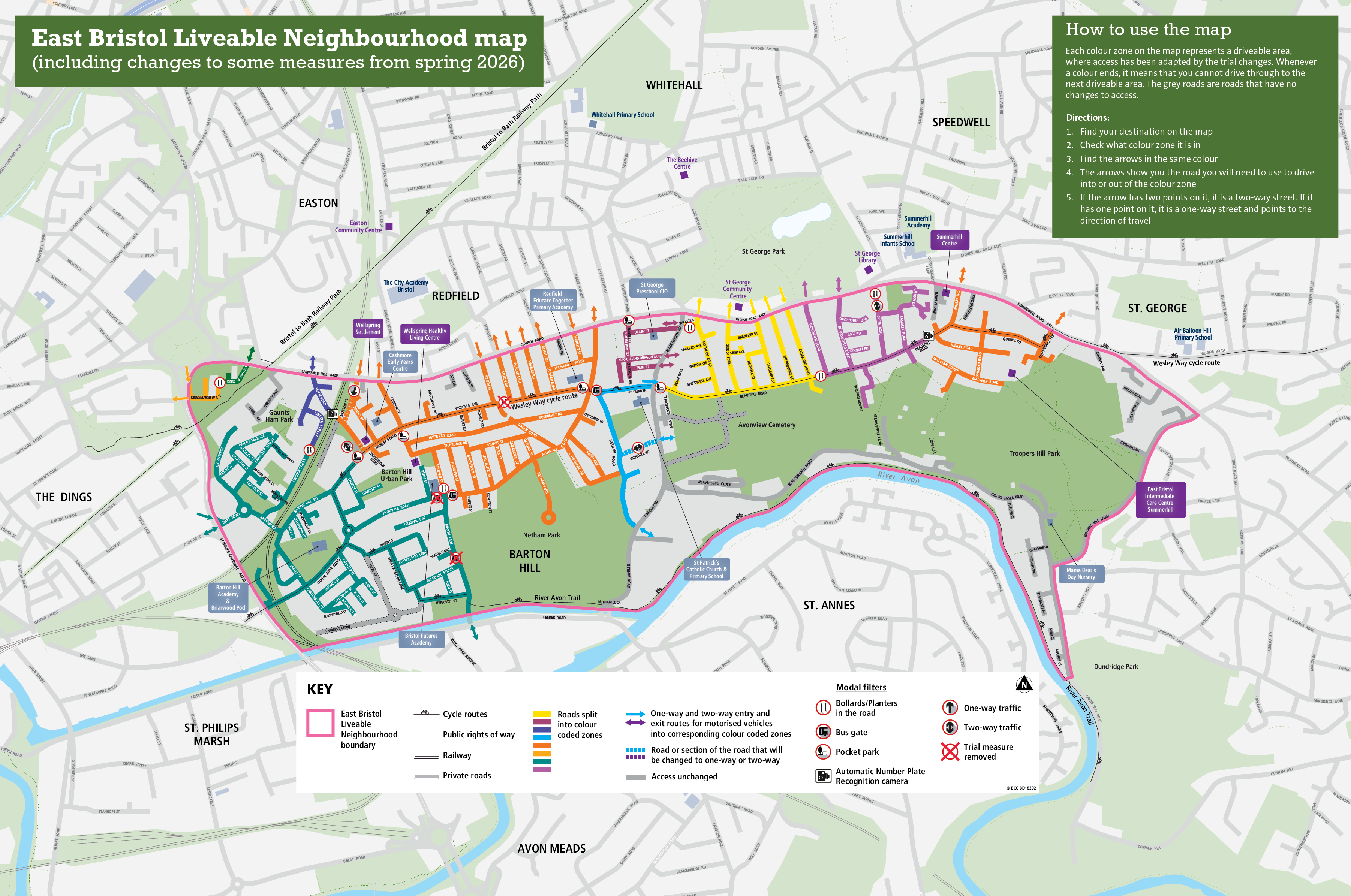
Large version of liveable neighbourhood map
All addresses within the area are still accessible by car, although your route may change. Find out more about getting around the trial scheme area in this video:
Sign up to our newsletter for updates on the East Bristol Liveable Neighbourhood trial scheme.
We selected Barton Hill and parts of Redfield and St George for the first Liveable Neighbourhood pilot area for several reasons.
Funding
Funding was made available, from the Department for Transport's City Region Sustainable Transport Settlement, secured by the West of England Mayoral Combined Authority, to develop schemes within the sub-regional Local Walking and Cycling Investment Plans. This identifies a cycling route, the Wesley Way parallel to Church Road, as a priority for investment. Find out more about the local cycling and walking infrastructure plan.
Engagement
The east Bristol project area covers a diverse area of Bristol. This will provide the opportunity to pilot different methods of engagement, which could inform how similar projects are introduced in the future.
Near to the city centre
The project area is within a short walking and cycling distance of the city centre, which makes walking, cycling and scootering a realistic option for commuter journeys.
Near other major developments
The area is near to major developments, such as Temple Island and the new University of Bristol campus. These developments are likely to attract more car journeys, which cannot be accommodated by the transport network.
Near the Clean Air Zone
The project area is close to the boundary for the Clean Air Zone, which launched in November 2022. Concerns have been raised that additional vehicles may cut through the area to avoid the charges, which will increase the transport issues that have already been reported to us.
Near to cycling routes
The project area is close to walking and cycling routes, such as the Bristol to Bath Railway Path and the River Avon Trail, which are often very busy at peak times. Improving alternative routes can help alleviate this pressure.
We're monitoring the scheme throughout the trial. This will help us:
- understand the impact measures are having on general traffic, active travel and bus services
We're collecting data on:
- traffic, walking and cycling levels
- bus journey times
- air quality
Find out more about trial scheme monitoring.
We expect there to be some disruption as people adjust to the changes. However, evidence from around the country has shown that over time traffic levels reduce within the scheme area and that traffic on main roads remains at a similar or lower level. This is because people tend to either switch their mode of transport or change their route.
Finding out what people think and their lived experience is also critical for us to understand the impact of the scheme and what changes may be needed before any measures are made permanent.
Our East Bristol Liveable Neighbourhood trial scheme monitoring strategy.
Co-discover: January to July 2022
Understanding what people love and what they would change in their neighbourhood. Mapping the current barriers to a more liveable neighbourhood.
Co-discover Engagement Report July 2022
Co-develop: September 2022 to March 2023
Gathering detailed community aspirations utilising the design toolkit to help shape the Liveable Neighbourhood.
Co-develop Engagement Report, February 2023
Trial scheme information sharing: May to June 2023
Sharing the plan, including a map, for the liveable neighbourhood that was developed with the community.
Statutory consultation: January to February 2024
Statutory consultation process for Traffic Regulation Orders.
Statutory objection report, March 2024
Trial scheme delivery: Spring 2025
Once the main trial measures have been installed, a period of data collection will begin.
Rapid review of consultation and engagement: September 2025
A pdf review of the consultation and engagement(390 KB) phases of the scheme and recommendations for future actions.
Public engagement: September to November 2025
Including a survey and independent polling.
Engagement and monitoring reporting: December 2025
Read our latest monitoring data report and public engagement findings:
pdf EBLN Monitoring Report 2025(14.81 MB)
pdf EBLN Engagement Report 2025(1.83 MB)
pdf EBLN Engagement Report 2025 Appendix A - Perception survey full details(4.39 MB)
pdf EBLN Engagement Report 2025 Appendix B - Full Polling Report(3.92 MB)
pdf EBLN Engagement Report 2025 Appendix C - WECIL audit recommendations(103 KB)
pdf EBLN Engagement Report 2025 Appendix D - Citizens' Observatory Report(135 KB)
pdf EBLN Engagement Report 2025 Appendix E - Poster locations and letter examples(418 KB)
pdf EBLN Engagement Report 2025 Appendix F - Perception survey letter to residents(200 KB)
Transport and Connectivity Committee to agree next steps: 2026
A decision as to whether the scheme should be made permanent.