
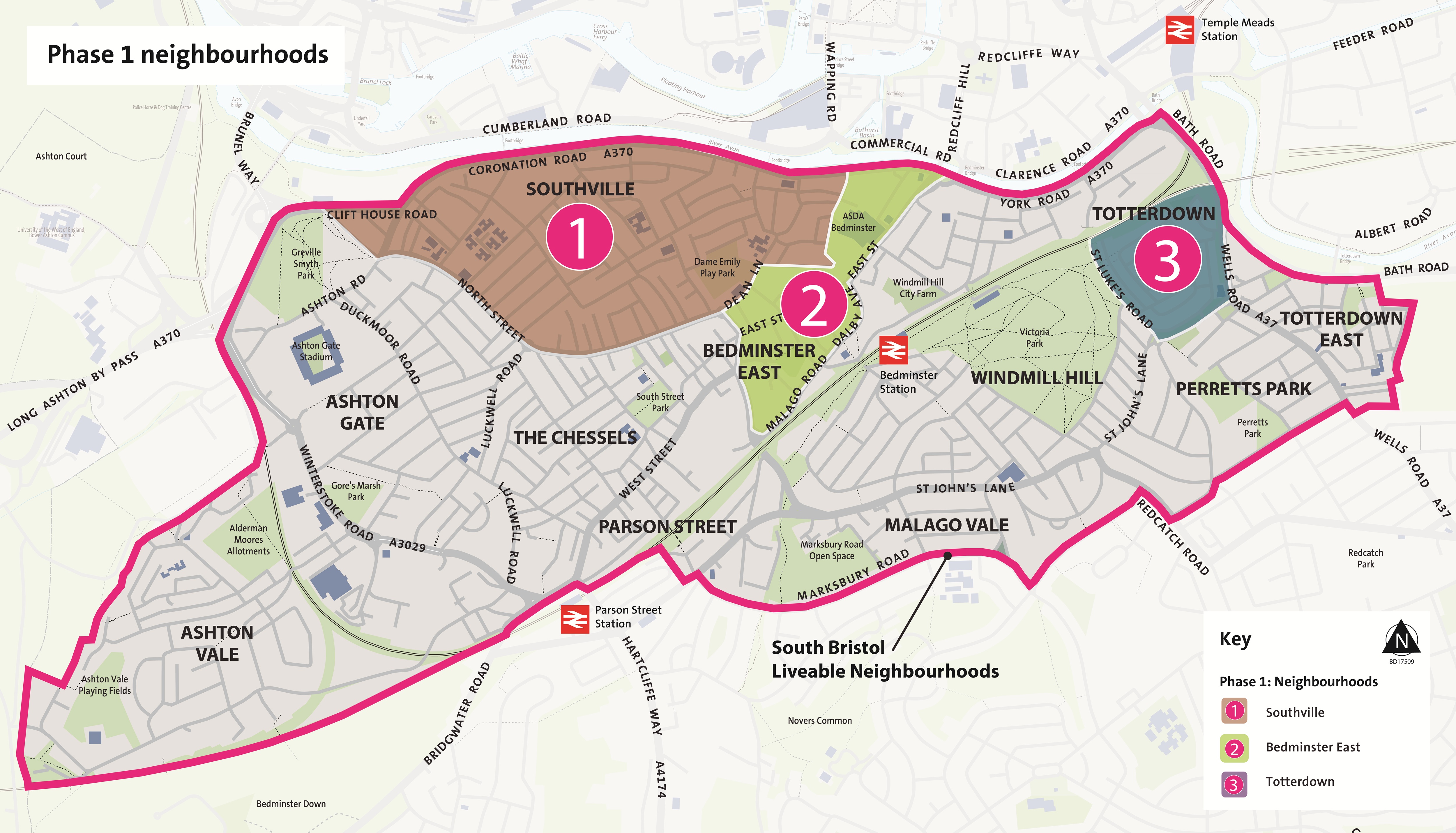
We propose some parking measures in all parts of the SBLN area. Based on your feedback and our review of the SBLN area, we propose 11 parking areas. The boundaries of these parking areas are the same as the boundaries proposed for the 11 liveable neighbourhoods, with a couple of exceptions. We think different types of parking measures - Residents' Parking or Matchday Parking or both Residents' Parking and Matchday parking in combination - would meet the needs of the 11 different areas.
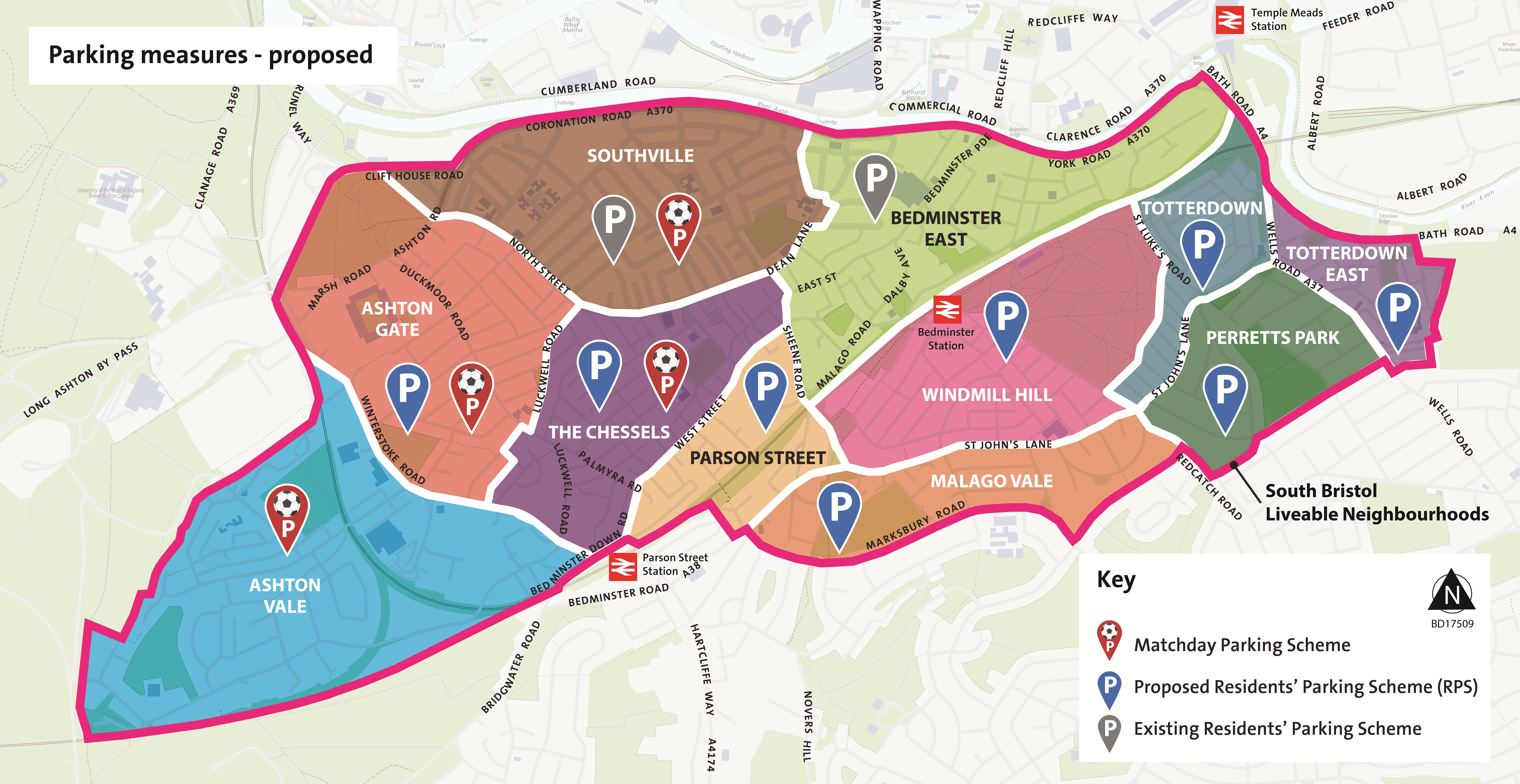
Two of the areas, Southville and Bedminster East, already have a residents parking scheme.
We propose:
- one area with an existing Residents' Parking Scheme (no Matchday Parking Scheme): Bedminster East existing RPS area
- one area with an existing Residents' Parking Scheme plus a new Matchday Parking Scheme: Southville existing RPS area
- 2 areas with a new Residents' Parking Scheme plus a new Matchday Parking Scheme: Ashton Gate, The Chessels
- 6 areas with new Residents' Parking Schemes (no Matchday Parking Scheme): Parson Street, Windmill Hill, Malago Vale, Totterdown, Totterdown East, Perretts Park
- 1 area with a new Matchday Parking Scheme (no Residents' Parking Scheme): Ashton Vale
Times when parking measures would apply
A Residents' Parking Scheme would operate on weekdays (Monday to Friday) from 9am to 5pm as a minimum. This is to manage parking by commuters and visitors to the area. It could operate for longer hours if needed, for example weekday evenings or at weekends.
A Matchday Parking Scheme, if needed, would be timed to apply when there are matches or events at Ashton Gate Stadium that impact parking on surrounding streets. There would not be regular fixed times.
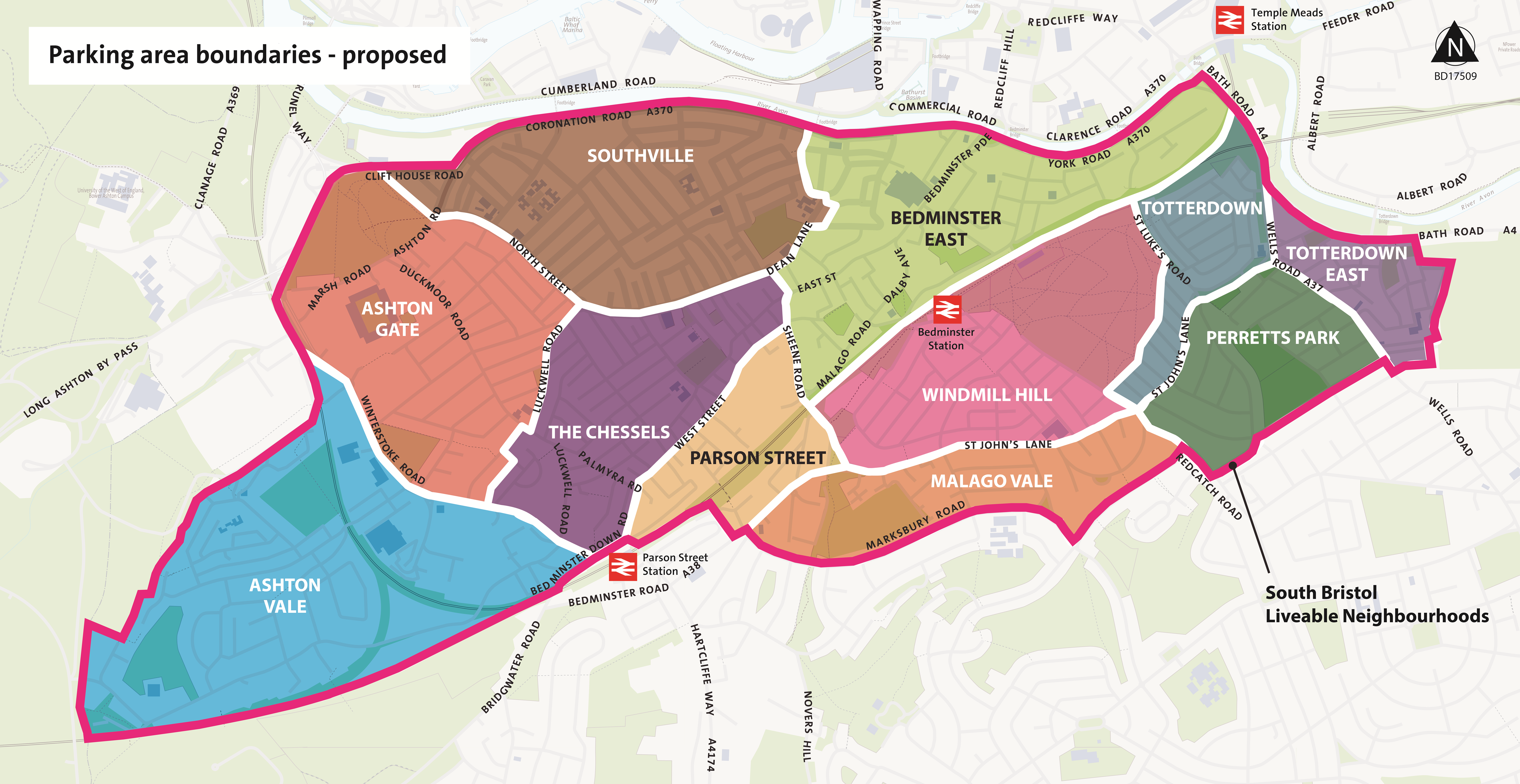
Parking area boundaries
The proposed parking area boundaries are shown below. The boundaries of the parking areas mostly match the proposed Liveable Neighbourhoods. In 2 locations, the parking scheme and Liveable Neighbourhood boundaries diverge. These are:
- Dean Lane, where the existing Southville Residents' Parking Scheme boundary follows Dean Lane. The proposed Liveable Neighbourhood boundary follows Catherine Mead Street, Lombard Street, and St John's Road.
- Totterdown, where the proposed Liveable Neighbourhood is bounded by St Luke's Road, St John's Lane and Wells Road. The proposed Totterdown Residents' Parking Scheme also includes streets between Hill Avenue and St John's Lane to provide a larger network of streets available within the parking scheme.
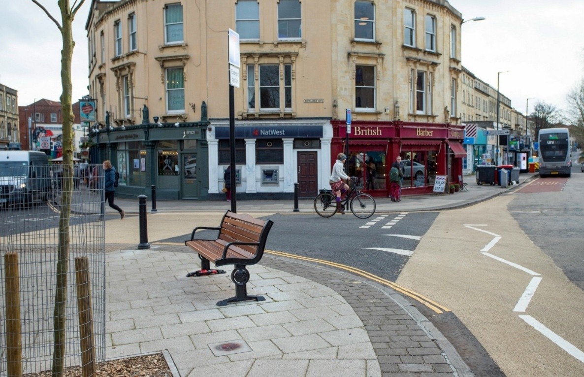
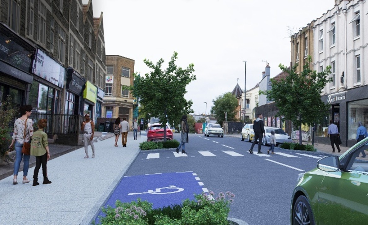
Most of the roads in South Bristol Liveable Neighbourhoods are residential streets. We propose that vehicles would be able to access all streets, but through-traffic would be discouraged or prevented, and lower speeds encouraged. Residential streets should be safe and comfortable for walking, wheeling and cycling, and attractive as social spaces.
During the 2024 engagement, you told us that clearer pavements, improved road safety and more trees and greenery are top priorities.
Types of measures on residential streets
On residential streets, we propose 2 types of measure:
- measures to reduce through-traffic and unsafe speeds
- measures to improve community space and help walking, wheeling and cycling
Measures to reduce through-traffic and unsafe speeds have most of the health and environmental benefits. To secure UK Government funding for this project from the West of England Mayoral Combined Authority, our designs must include these types of measures.
Measures to improve community space may reduce the amount of on-street parking spaces. If we introduce Residents' Parking Scheme or Matchday Parking Scheme, this could reduce the number of vehicles trying to park in the area and make it easier to create space for community measures.
Measures to reduce through-traffic and unsafe speeds
These may include:
- closing some roads to through traffic using modal filters or bus gates
- making traffic one-way
- traffic calming
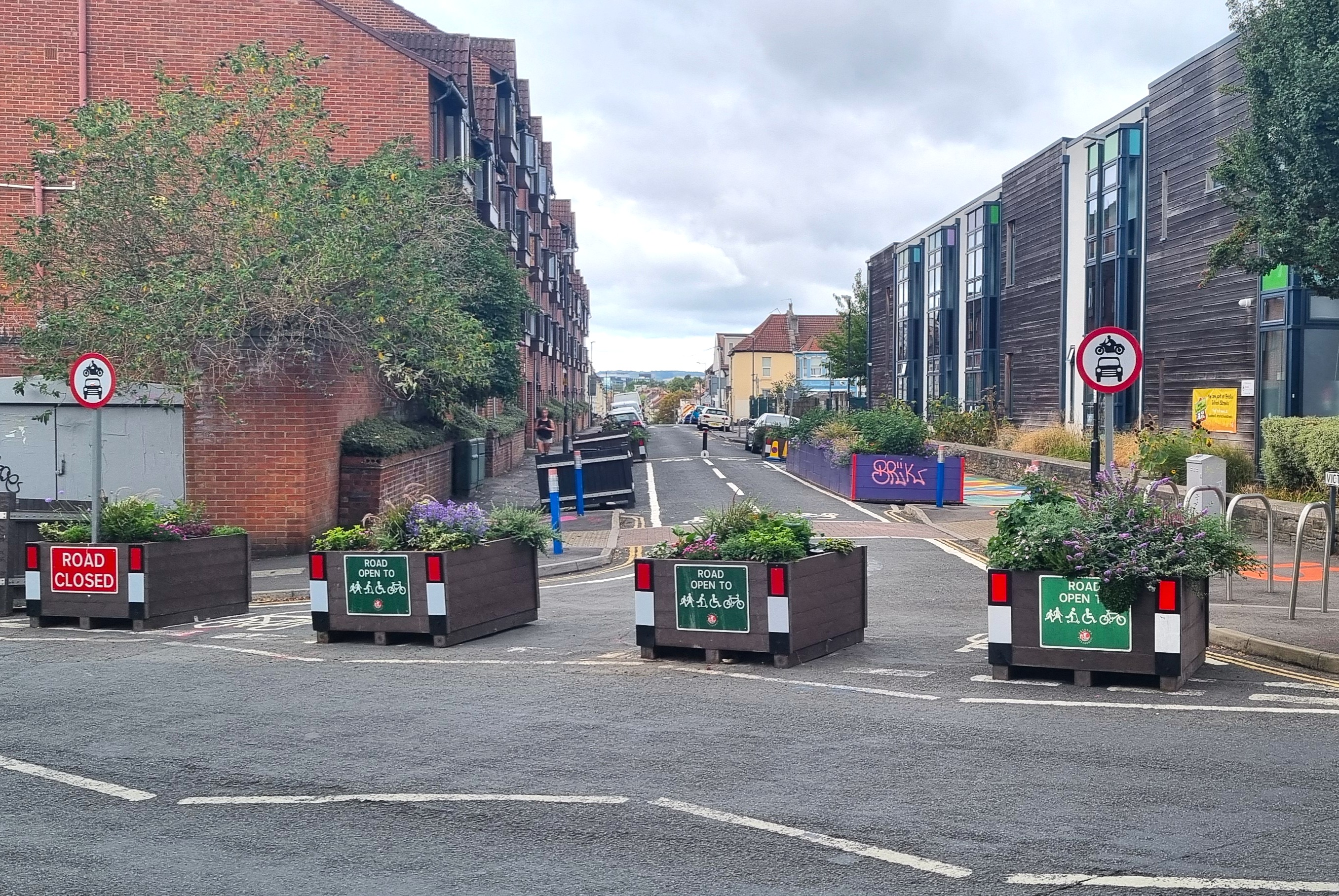
Modal filters
A modal filter can be used to prevent motor traffic driving through a neighbourhood, while allowing pedestrians and cycles to travel through. A modal filter can use bollards, planters or camera enforcement.Bus gates are a type of modal filter that allow buses and other authorised vehicles to travel through, as well as pedestrians and cycles. Bus gates are used on bus routes to improve bus journey times and reliability. A bus gate would be enforced by a camera. There would not be a physical barrier.
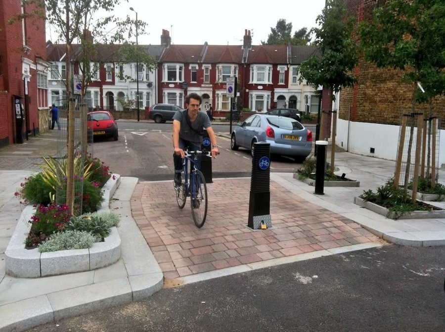
Example of a modal filter. Photo Credit Michael Poteliakhoff
Making traffic one-way
Making streets one-way can prevent vehicles from using the street as a shortcut. The street would remain two-way for cycles.
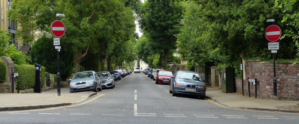
Example of a one-way street with two-way cycling permitted
Traffic calming
Traffic calming can be used to reduce vehicle speeds through measures such as road narrowing or pavement build-outs. We are not proposing widespread use of road humps.
Measures to improve community space
These may include:
- street trees and greening
- parklets
- visitor cycle parking
- cycle hangars
- electric vehicle (EV) chargers
- car club bays
- e-scooter and e-bike share parking areas
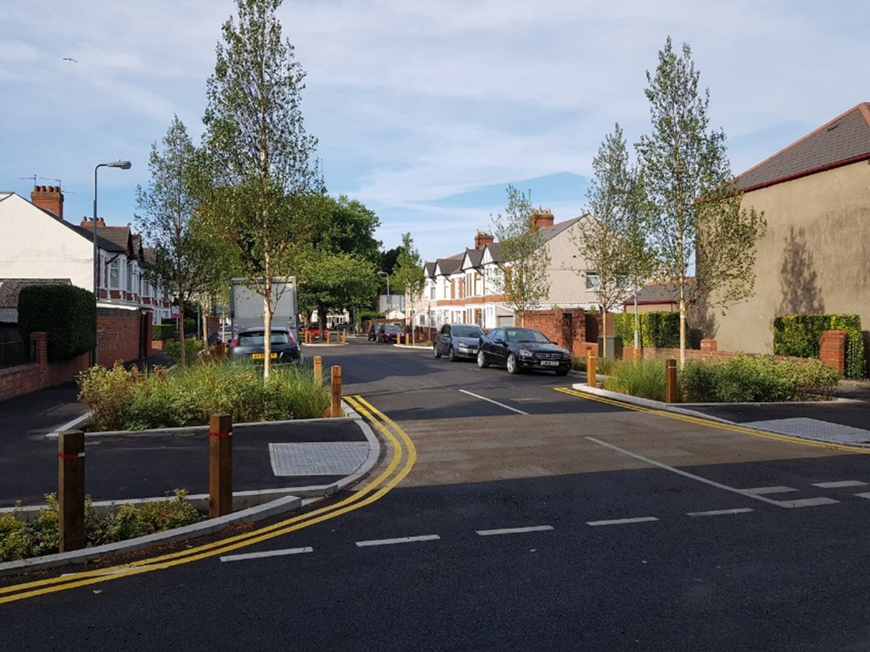
Street trees and greening
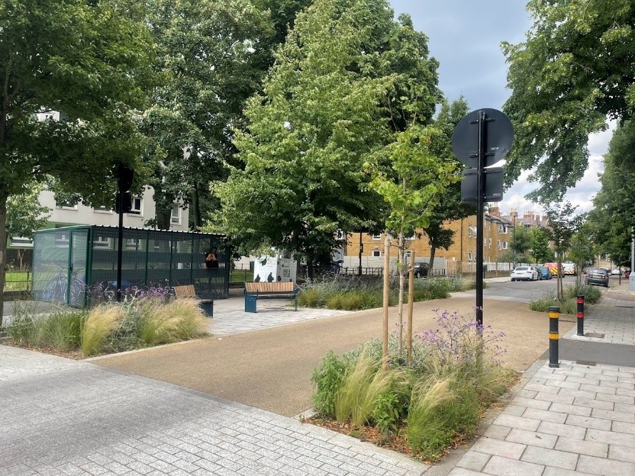
Trees and other planting can reduce vehicle speeds, reduce temperature on hot days and make streets more attractive and welcoming.
A tree pit containing 2 to 3 trees would take the space of at least one kerbside car parking space. We would need to do a survey to check where there is underground gas, electricity and telecoms to know where trees can be placed.
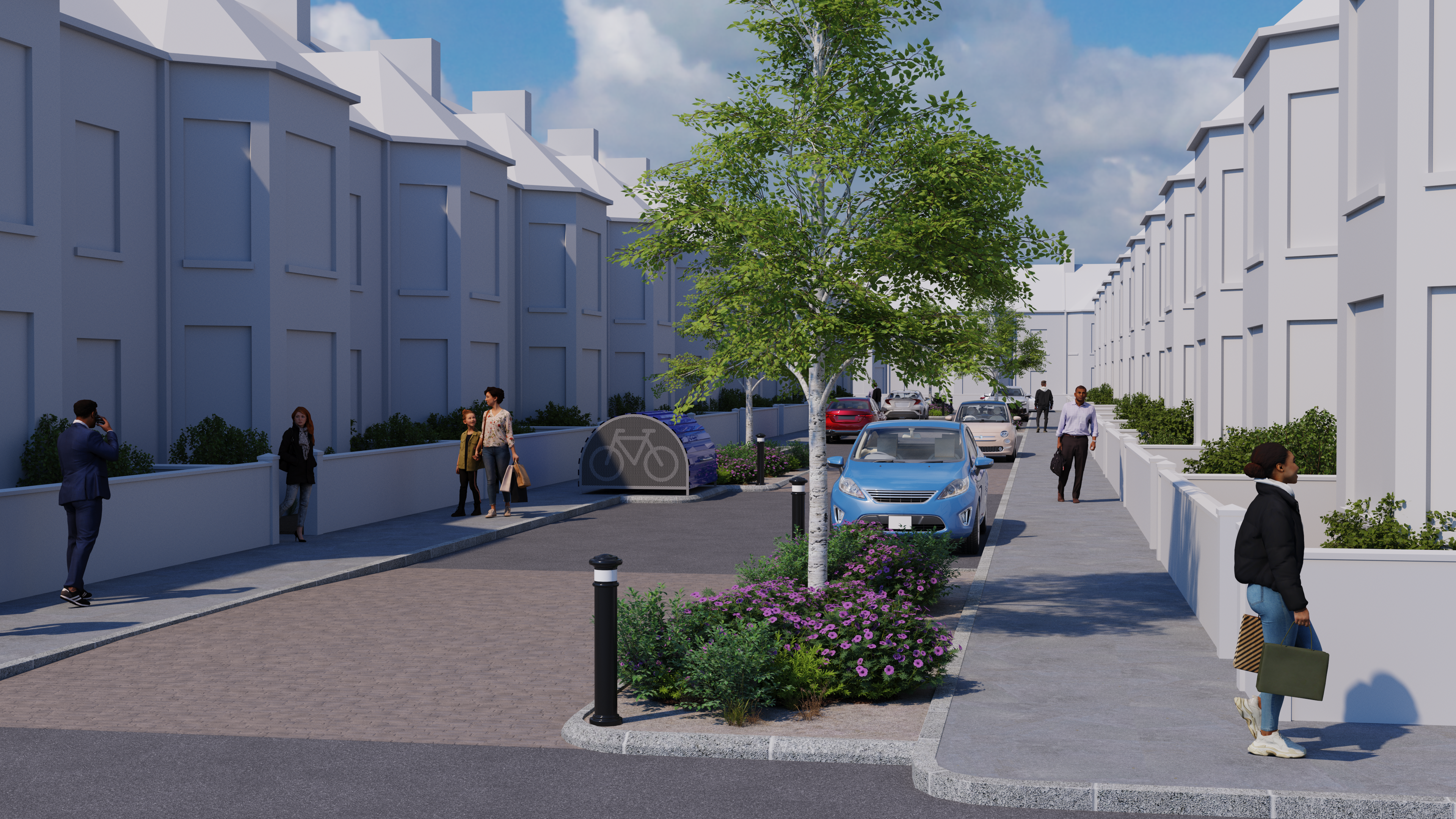
Artist's impression of street trees and other planting on a residential street
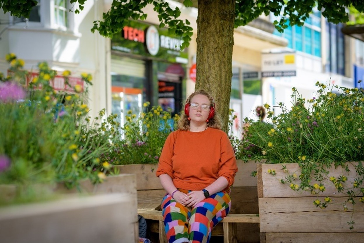
Parklets
A parklet is an area with seating and planting that usually replaces parking on a street.
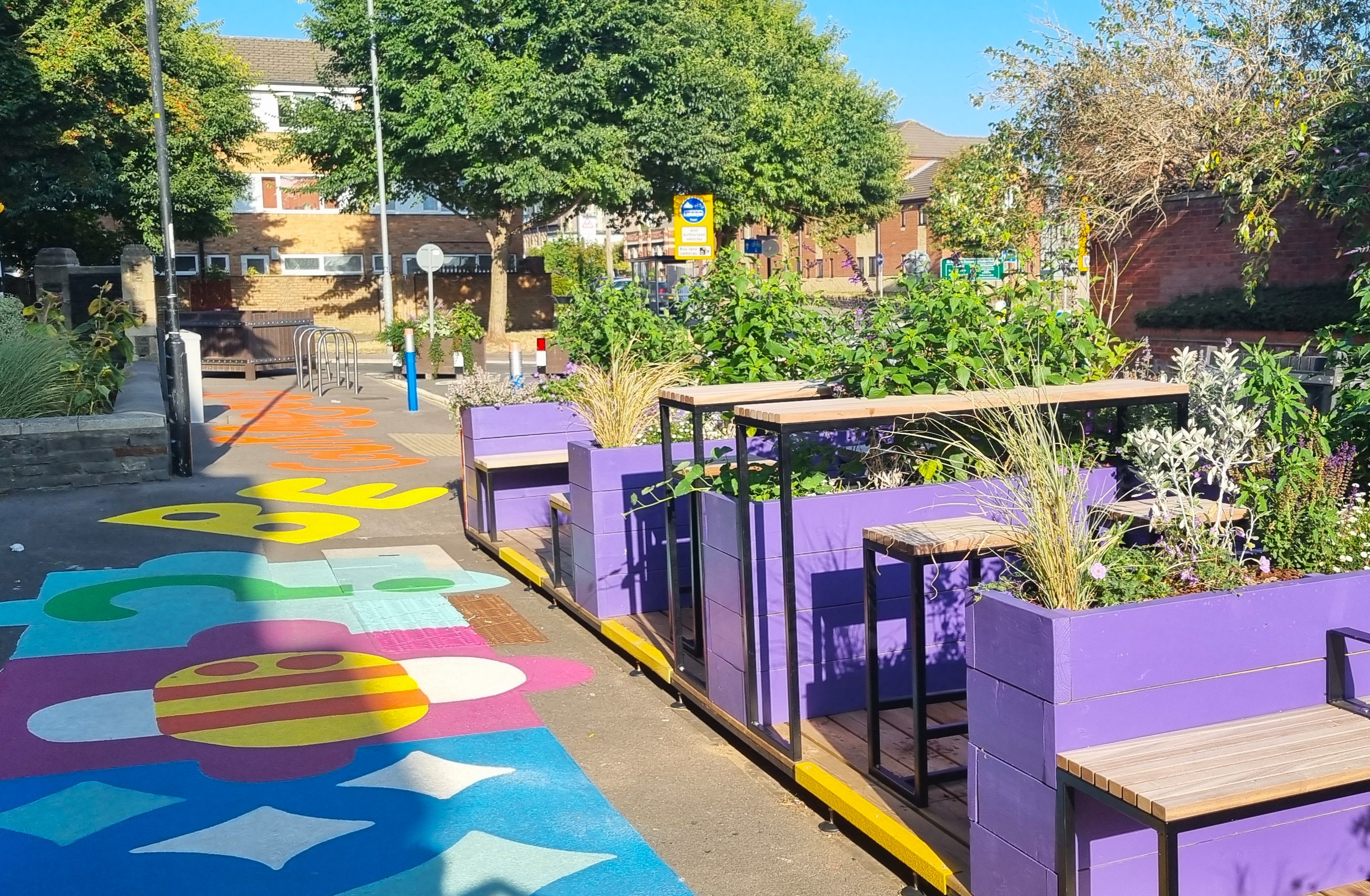
Example of a parklet
Visitor cycle parking
Cycle parking for visitors is Sheffield stands that can be used to park up to 10 bicycles in the space of one car.
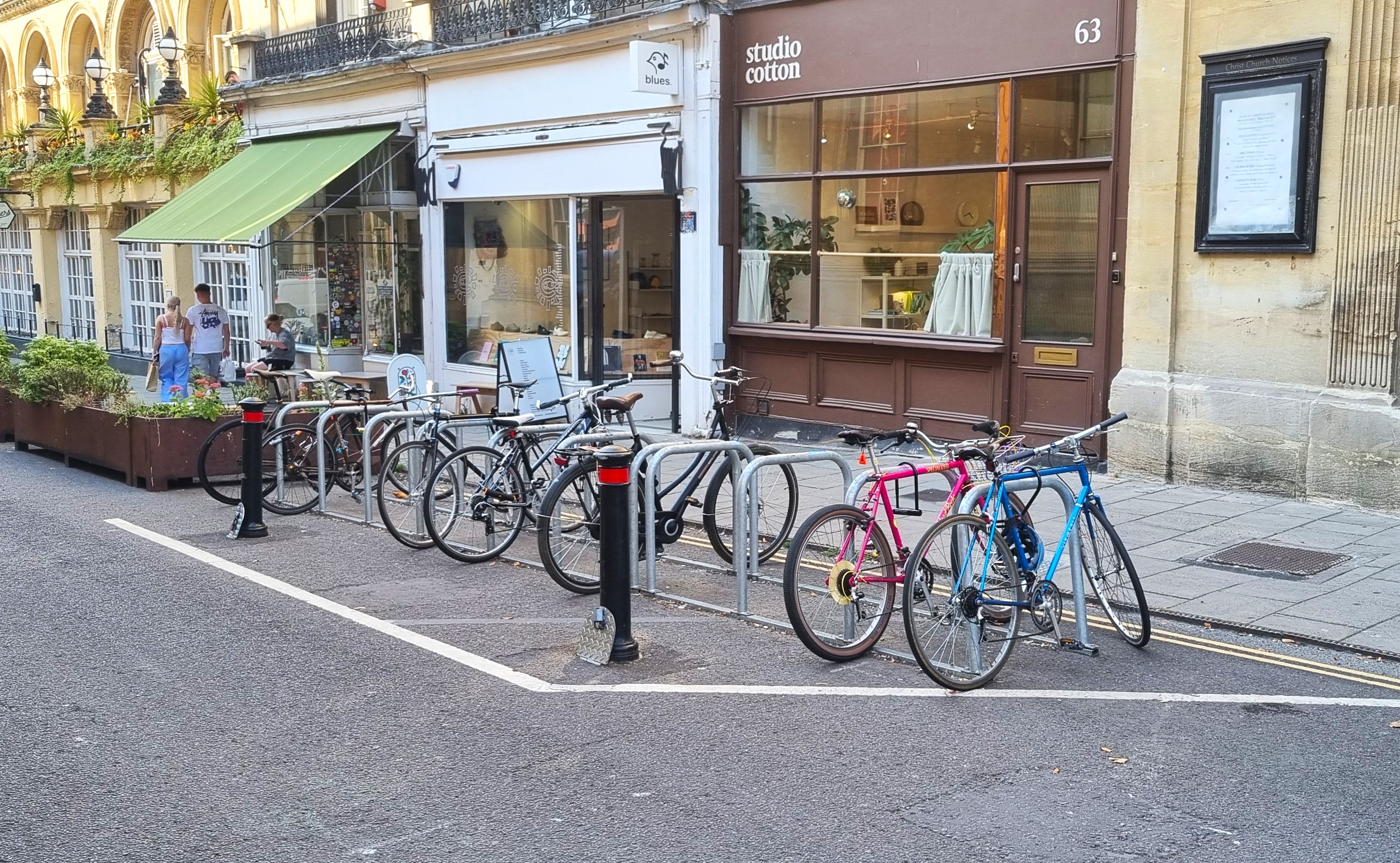
Example of visitor cycle parking using Sheffield stands
Cycle hangars
Cycle hangars are secure, covered cycle parking for residents. Each cycle hangar would take the space of one kerbside car parking space and can be used to park up to 6 bicycles.
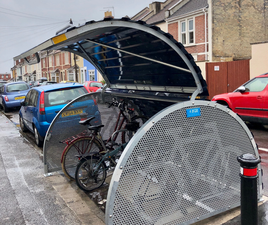
Example of a cycle hangar
Electric vehicle (EV) chargers
EV chargers would be installed into lampposts. These do not remove parking spaces. However, the adjacent section of kerb may only be used for electric vehicle parking.
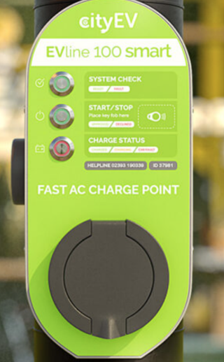
Example of an EV charging point in a lamppost
Car club bays
Car club bays are designated kerbside car parking spaces for car sharing vehicles. They cannot be used to park other vehicles but can increase space overall by helping to reduce car ownership.
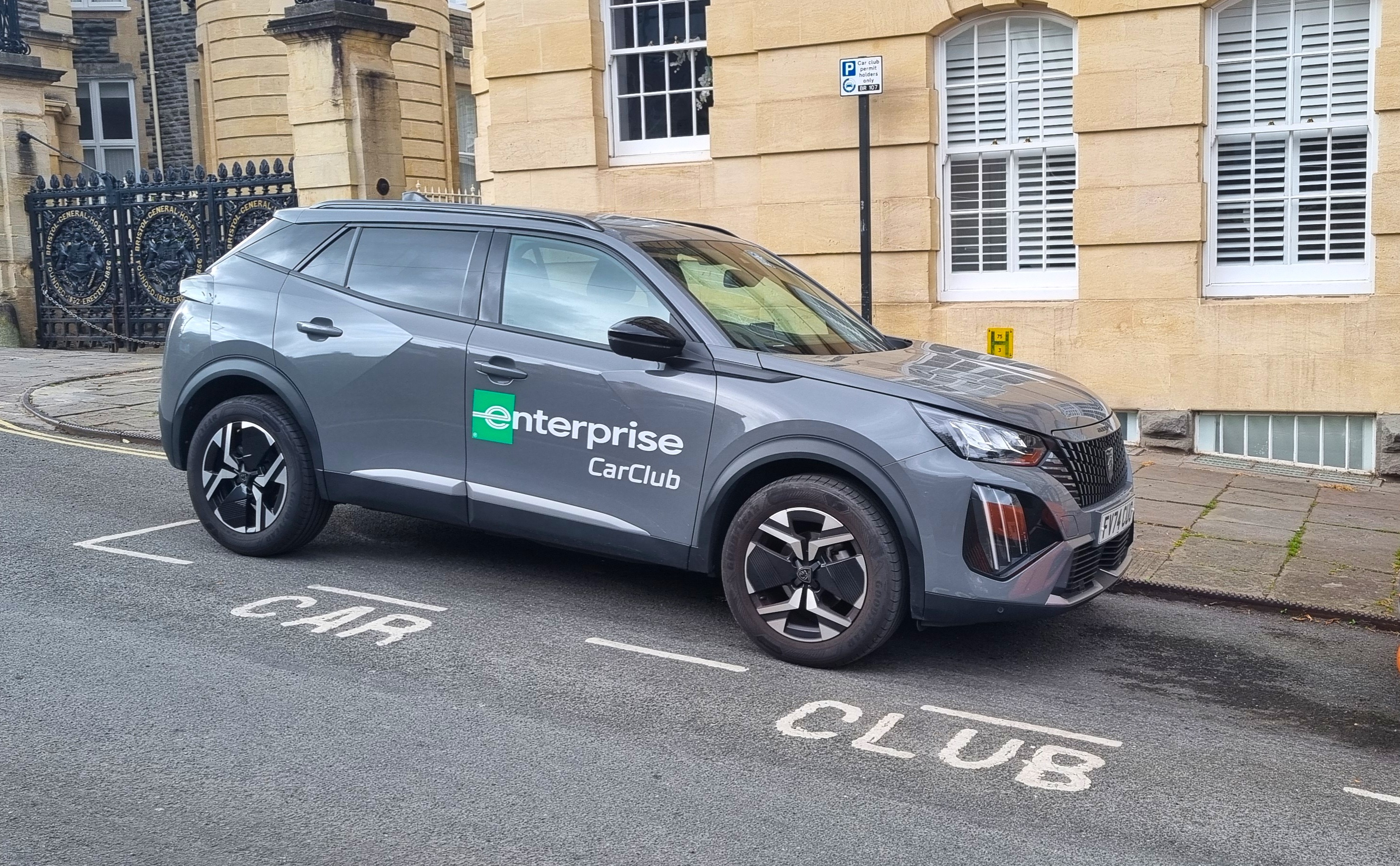
Example of a car club bay
E-scooter and e-bike share parking areas
These parking areas typically take one kerbside car parking space to store public e-scooters and e-bikes off the pavement. This can increase space overall by helping to reduce car ownership.
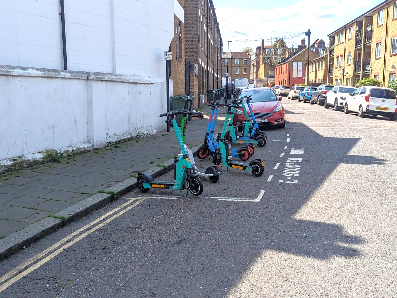
Example of a parking area for e-scooters
Connector roads run along the edges of each neighbourhood and form the connections between neighbourhoods. Connector roads would be used by most of the vehicles passing through the area and connecting to other parts of Bristol. Bus routes would tend to use connector roads, and they would also be important routes for walking, wheeling and cycling. This would mean there would be less traffic on other residential streets.
During the 2024 engagement, you told us speeding and volume of traffic are big issues and safety for pedestrians and cyclists are top priorities on most connector roads. You also suggested improvements including:
- safe crossings and junctions
- wider/clearer pavements
- priority for people walking and cycling at side road junctions
- protected cycle tracks
The roads we propose are connector roads
We propose that the following roads are connector roads. These are shown in the map below.
- Coronation Road
- Ashton Road / Marsh Road
- Duckmoor Road / Luckwell Road (south)
- A3029 Winterstoke Road
- Malago Road
- Bedminster Parade
- Catherine Mead Street
- Dean Lane (from North Street to Catherine Mead Street)
- St John's Road (between Coronation Road and Catherine Mead Street)
- B3120 Cannon Street / East Street / Sheene Road
- St John's Lane
- Bedminster Road
- Redcatch Road
There are 3 roads that have a similar movement function to the connector roads but are also categorised as high streets because they have a wider range of functions as local destinations. These are:
- North Street (a high street and connector road)
- West Street (a high street and connector road)
- Wells Road (a high street and connector road for part of its length)
East Street and a section of Oxford Street in Totterdown are also high streets but do not have the movement function of a connector road. We describe our proposals for high streets and high streets that are also connector roads in the next section.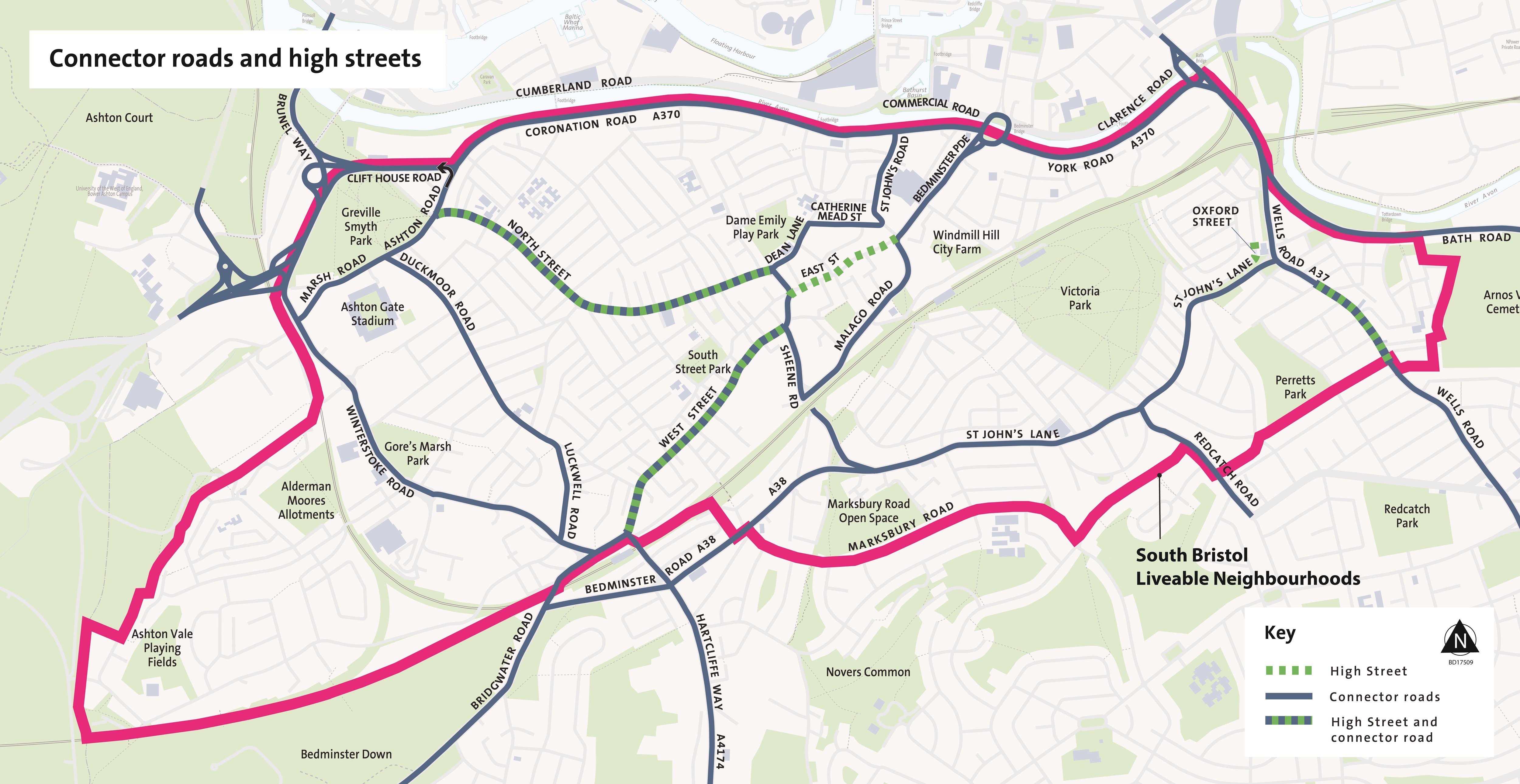
Types of measures on connector roads
On connector roads, the types of changes we propose would make it safer and more convenient to walk and cycle and to cross the roads. These include:
- pedestrian crossing points
- side road junction improvements
- traffic calming – this would be designed to be suitable for bus routes
- wider pavements
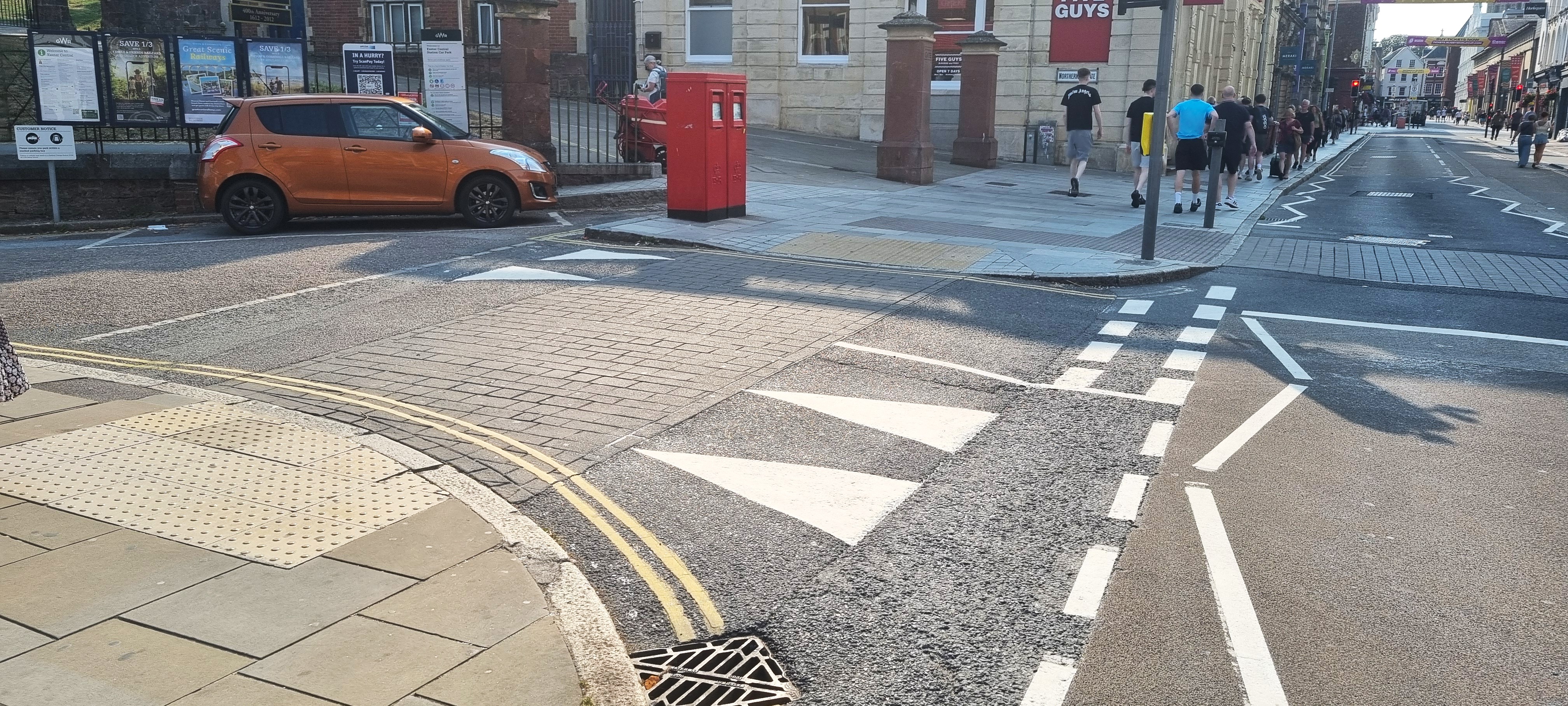
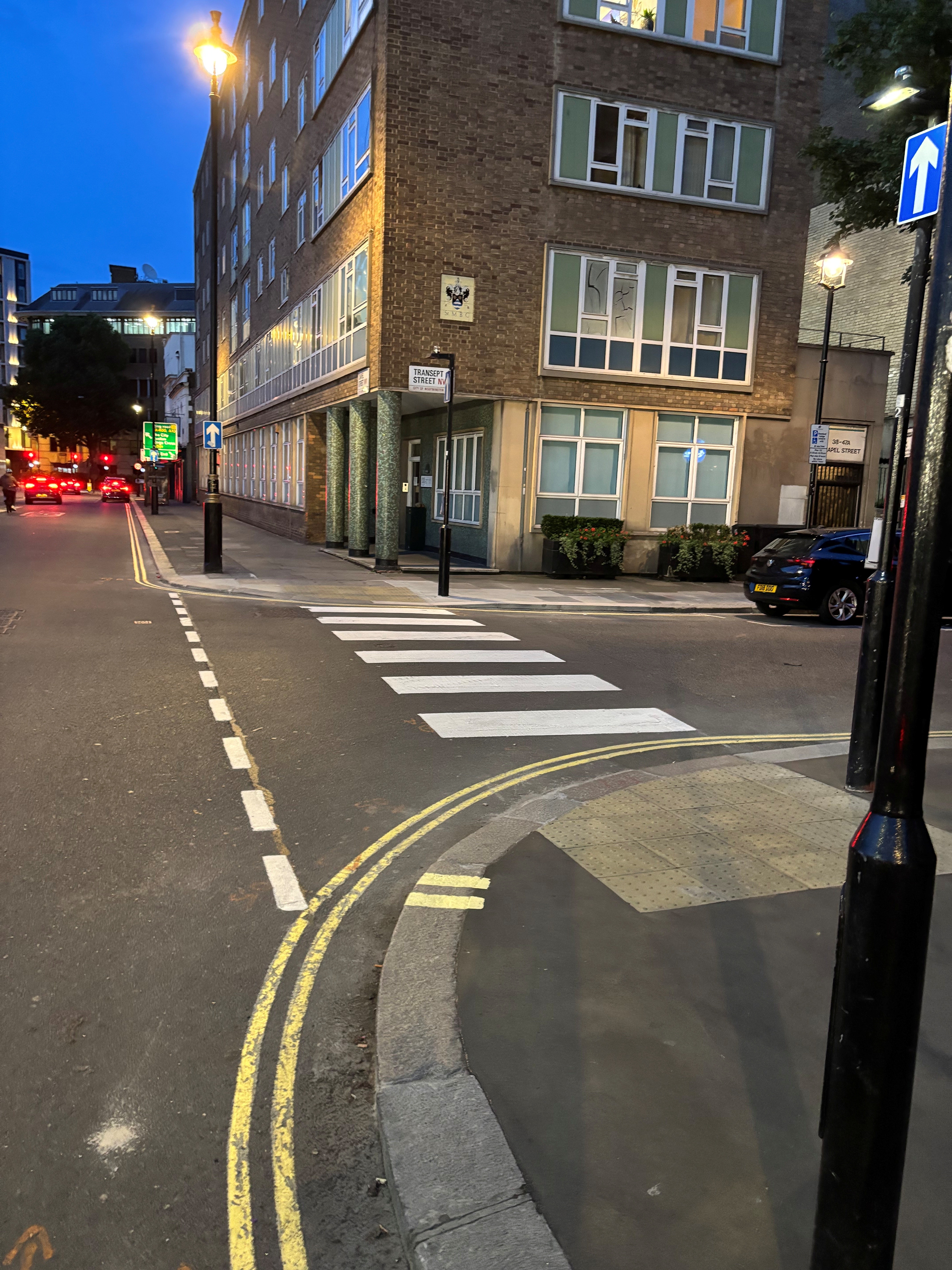
Pedestrian crossing points
At pedestrian crossing points, a small section of the pavement is lowered to the level of the road and tactile surface is added to help visually impaired people find the crossing point. In some cases, there may also be a pedestrian island in the middle of the road to make crossing easier on busy roads.
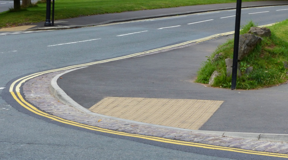
Example of a pedestrian crossing point
Side road junction improvements
This could include:
- narrowing the side road entry and raising the road to pavement level at the junction to encourage vehicles to slow down and give way to pedestrians
- zebra crossing markings across side roads to encourage vehicles to slow down and give way to pedestrians. These would also improve safety for cyclists.
Side-road junction improvement with the road narrowed and raised to pavement level
Side-road junction improvement with zebra markings
Traffic calming
Traffic calming can be used to reduce vehicle speeds through measures such as road narrowing or pavement build-outs. We are not proposing widespread use of road humps. Traffic calming would be designed to be suitable for bus routes.
Wider pavements
Widening pavements can help to slow traffic and make it easier to cross the road, as well as creating more space for pedestrians and seating.
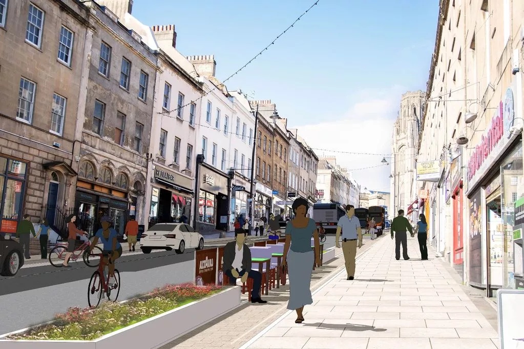
Artist's impression of widened pavements
Note, traffic calming and wider pavements are likely to be suitable on the following roads only:
- Cannon Street
- Duckmoor Road
- North Street (a high street and connector road)
- West Street (a high street and connector road)
High Streets have a mix of functions. They are key destinations for shopping and leisure. Some have a movement function similar to connector roads, including being bus routes. They are also important social spaces.
In the 2024 engagement, you told us that the biggest issues for high streets were:
- lack of crossings
- unsafe for cyclists
- narrow pavements
You proposed the following solutions for these issues:
- safe crossings and junctions to make it easier to cross the road
- protected cycle tracks
- wider and clearer pavements
You also said that high streets could be improved with more seating for local businesses and more trees and greenery.
The roads we propose are high streets
North Street, West Street, East Street, part of Wells Road and a section of Oxford Street in Totterdown are designated high streets in the Local Plan. These streets combine shopping, leisure and social functions and some carry significant local and through traffic.
As part of this project, we propose to focus improvements on North Street, West Street, the section of Oxford Street in Totterdown, and at ‘gateways' at each end of East Street.
Types of measures on high streets
On high streets the type of changes we propose would make the streets more attractive, support local businesses and make it easier to walk and cycle. These include:
- pedestrian crossing points
- side road junction improvements
- traffic calming
- pavement widening
- seating
- street trees and greenery
- spill out space in the street for bars and cafes
- arts and culture programming
- visitor cycle parking
The first 4 of these measures — pedestrian crossing points, side road junction improvements, traffic calming and pavement widening — are the same measures we propose on connector roads (described above). The additional measures for high streets are described below.
Seating
Seating can provide spaces to stop and rest. This supports the role of high streets as social spaces and is important for people with mobility difficulties.
Example of seating on a high street
Street trees and greenery
Trees and other planting can reduce vehicle speeds, improve air quality, create shade that helps reduce high temperatures on hot days and make streets more attractive and welcoming.
Artist's impression of street trees on North Street
Spill out space in the street for bars and cafes
Using some of the road that was previously used for moving traffic or parking can make the street more vibrant and welcoming and help to support local businesses.
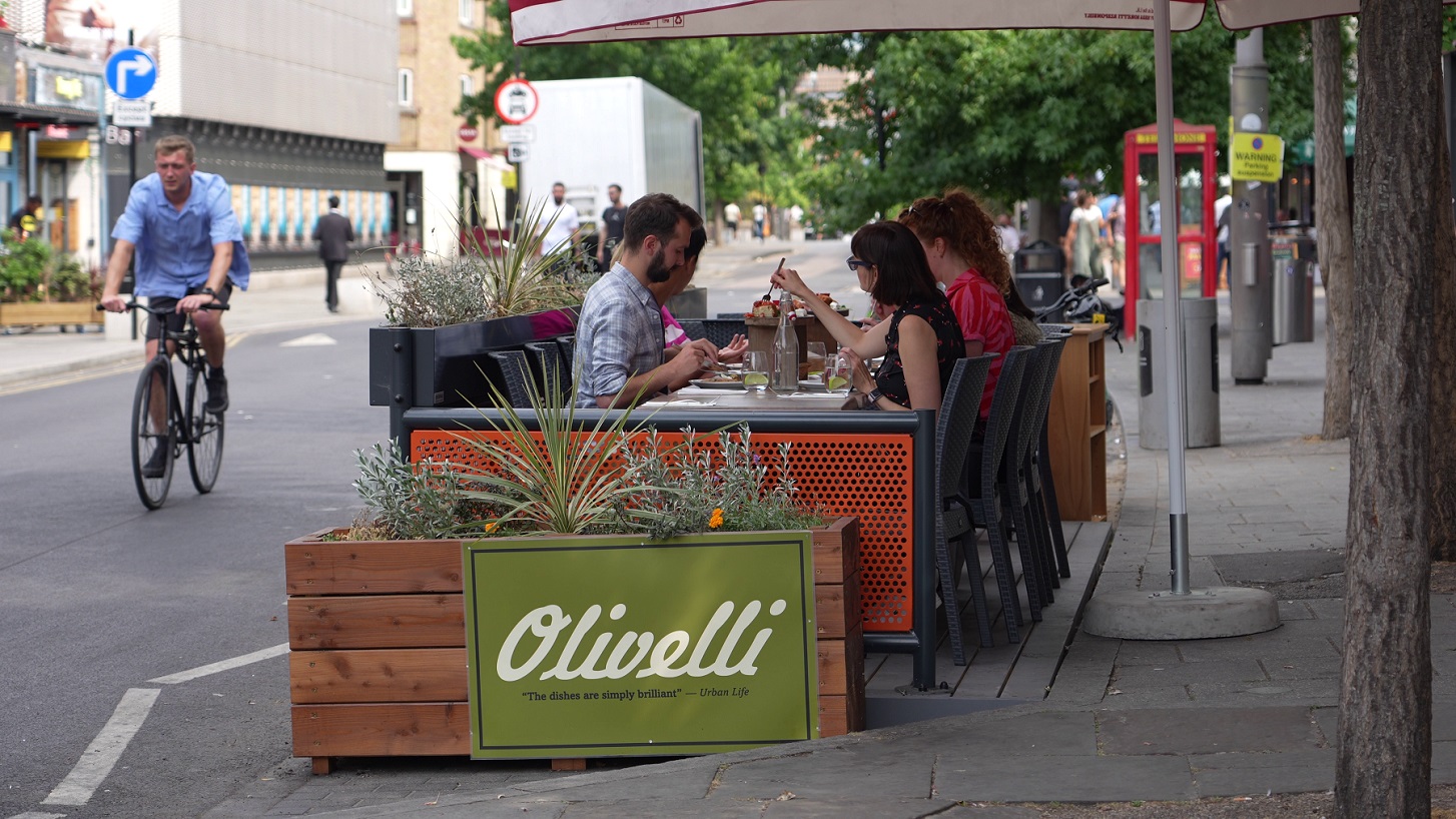
Example of a spill out space for restaurant seating on the edge of a road
Arts and culture programming
Arts and culture programming such as events, activities and creative initiatives, can encourage safe play, movement and opportunities to connect with each other. We will be offering opportunities for businesses, communities and local people to get involved in creative initiatives that contribute to arts and culture programming.
Arts and culture example: Broadmeadow wildflower installation and audio experience 2023 by artists Sylvia Rimat and Charli Clark, Photo Credit Paul Blakemore
Visitor cycle parking
Cycle parking for visitors uses Sheffield stands that can be used to park up to 10 bicycles in the space of one car.
Visitor cycle parking (Sheffield stands)
Many of these measures would reduce the amount of on-street parking on these roads. We are aware that there are also some requests for more pay and display parking and Disabled parking spaces. We would work to balance these different priorities.
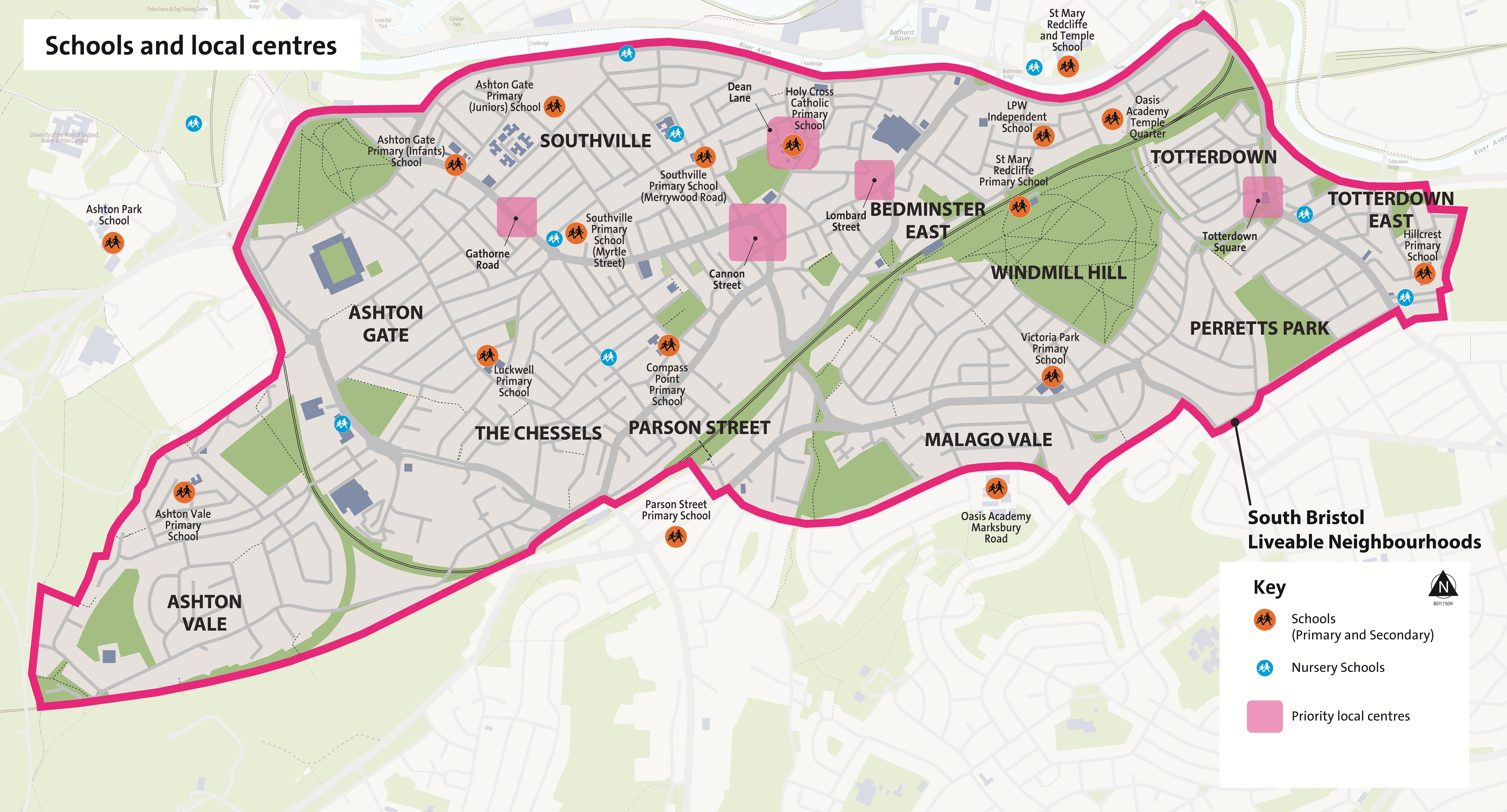
Streets with schools and local centres are sensitive sites used by large numbers of pedestrians, including children. They need to be safe and attractive locations where the speed and volume of traffic is carefully managed.
There are 13 schools in the South Bristol Liveable Neighbourhoods area and another 4 schools just outside the area.
There are 5 local centres in the Phase 1 neighbourhoods and other local centres in the 8 Phase 2 neighbourhoods.
In the engagement in 2024, you told us that safe routes to school, space for children to play and improving community spaces were top priorities in the area.
In Phase 1 (by end 2027), we are proposing the following measures near all schools within the SBLN area and around the 5 local centres in the Phase 1 neighbourhoods:
- measures to reduce the speed and amount of traffic
- other improvements to make it easier and more pleasant to walk and spend time outside
On streets with schools and local centres, the type of changes proposed would be:
- measures to improve road safety by reducing the speed and amount of traffic, such as:
- modal filters
- School Streets
- traffic calming, such as pavement build-outs to slow traffic
- improvements to make it easier and more pleasant to walk and spend time outside:
- improved walking routes, including crossing points and pavement widening
- greenery - trees, planters and ground level planting
- arts and culture programming
Measures to reduce the speed and amount of traffic
Modal filters
Modal filters can be used to close some small roads outside entrances to schools. Access for residents would remain.
Example of a modal filter
School Streets
School Streets restrict access for non-essential traffic at the start and end of the school day. This is when most children are walking or cycling near the school and there is most parking pressure due to people dropping off or picking up children in vehicles.
While the restriction is in place, only people walking, wheeling, cycling, and scooting are permitted access to the School Street zone, with exemptions given to emergency vehicles and blue badge holders.
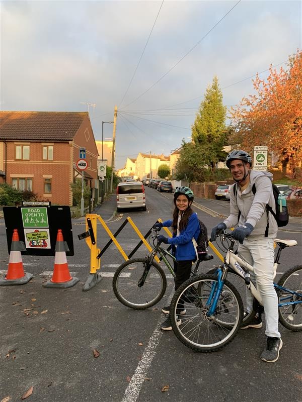
Example of a School Street
Traffic calming
Traffic calming can be used to reduce vehicle speeds through measures such as road narrowing or pavement build-outs. We are not proposing widespread use of road humps.
Improvements to make it easier and more pleasant to walk and spend time outside
Improved walking routes
Walking routes could be improved by providing more space for pedestrians and better crossing points. The example below shows buildouts to slow traffic and reduce the crossing distance at a side road junction.
Improved walking routes
Greenery - trees, planters and ground level planting
Trees, planters and ground level planting can reduce vehicle speeds, reduce temperature on hot days and make streets more attractive and welcoming.
Example of new trees and street level planting
Example of arts and culture measures that local school children helped design alongside an artist
We have designed proposals for 3 Phase 1 neighbourhoods where we are proposing the most changes by March 2027. These areas have been selected based on the number of traffic concerns and the level of support expressed in the 2024 engagement, their closeness to the city centre and strong links to the existing transport network.
These are:
- Southville (a defined neighbourhood, not the larger electoral ward)
- Bedminster East
- Totterdown
2 of these areas, Southville and Bedminster East, already have Residents' Parking Schemes.
The majority of measures for the remaining 8 neighbourhoods will be consulted on and delivered as part of Phase 2 of the project from 2027 onwards.
At this stage, we are consulting you on specific proposals to reduce through-traffic and unsafe speeds, including modal filters, bus gates and one-way streets.
The phase 1 neighbourhoods would also have measures to improve community space, including:
- street trees and greening
- parklets
- visitor cycle parking
- cycle hangars – secure resident cycle parking
- EV chargers – installed into lampposts
- car club bays – spaces for car sharing vehicles
- e-scooter and e-bike share parking areas
Southville's housing is mainly Victorian and Edwardian terraced homes, built before the motor car. The street layout has a grid-like street pattern and narrow roads. Local high streets and the city centre are within convenient walking distance. There are 5 school sites within this neighbourhood and 2 nearby secondary schools.
Traffic data show that high numbers of vehicles from outside the area use residential streets in Southville as a cut-through to other destinations.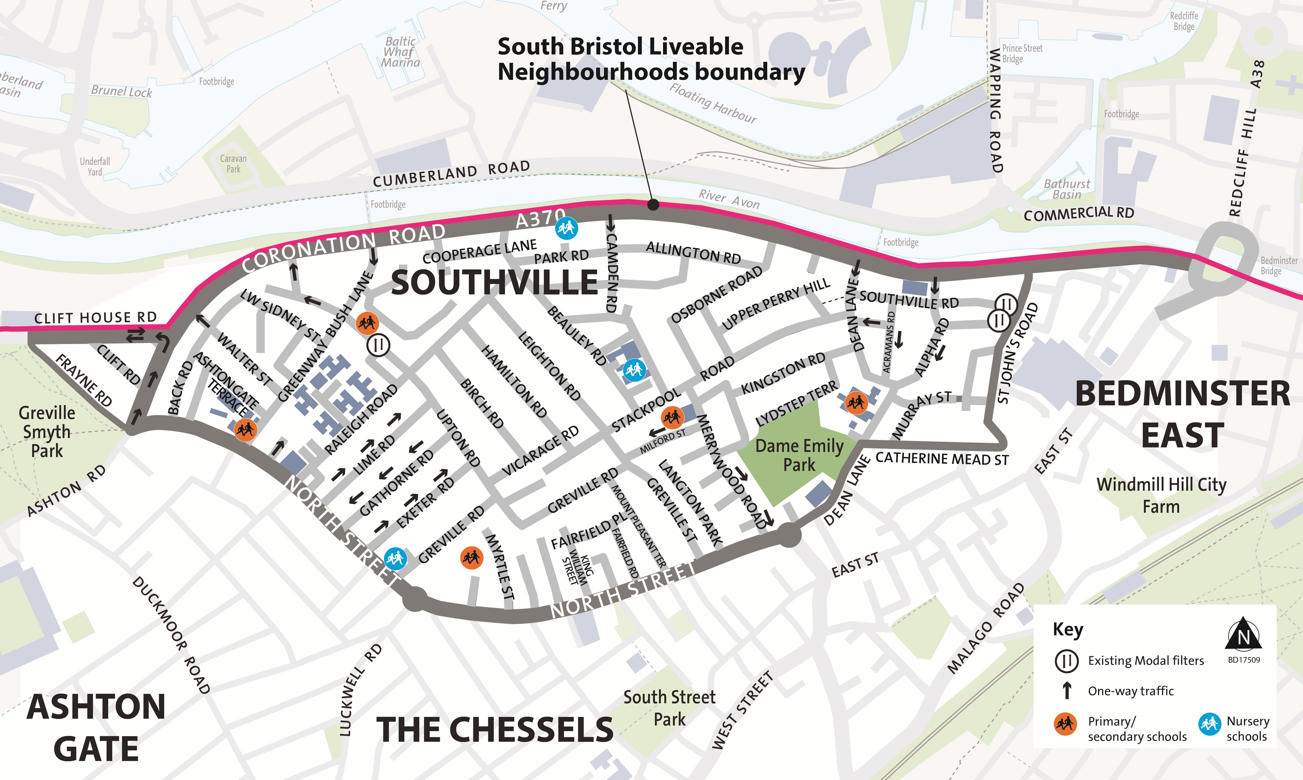
Larger version of existing traffic layout in Southville map
In the 2024 engagement, you told us that the top priorities for Southville are:
- safer routes to school
- addressing speeding traffic
- problems with car parking
You also suggested a number of improvements to address these, including:
- safe crossings and junctions
- wider / clearer pavements
- managing unsafe vehicle speeds
- modal filters and one-ways to give priority access to walking, cycling and public transport
- managing on-street car parking
We are proposing 3 types of measures for Southville neighbourhood:
- measures to reduce through-traffic and unsafe speeds
- measures to improve community spaces
- measures around schools and local centres
Measures to reduce through-traffic and unsafe speeds
We propose to install 12 modal filters in key locations to prevent cut-through traffic. Modal filters are bollards, planters, or cameras, which prevent motor vehicles passing through, while allowing access by walking, wheeling and cycling.
The modal filters would create 4 areas protected from through-traffic as shown on the proposed traffic layout map below. All properties would remain accessible, though routes may change. Removing through traffic would reduce traffic volume and speeds and would make the area safer and more pleasant for walking, wheeling, and cycling.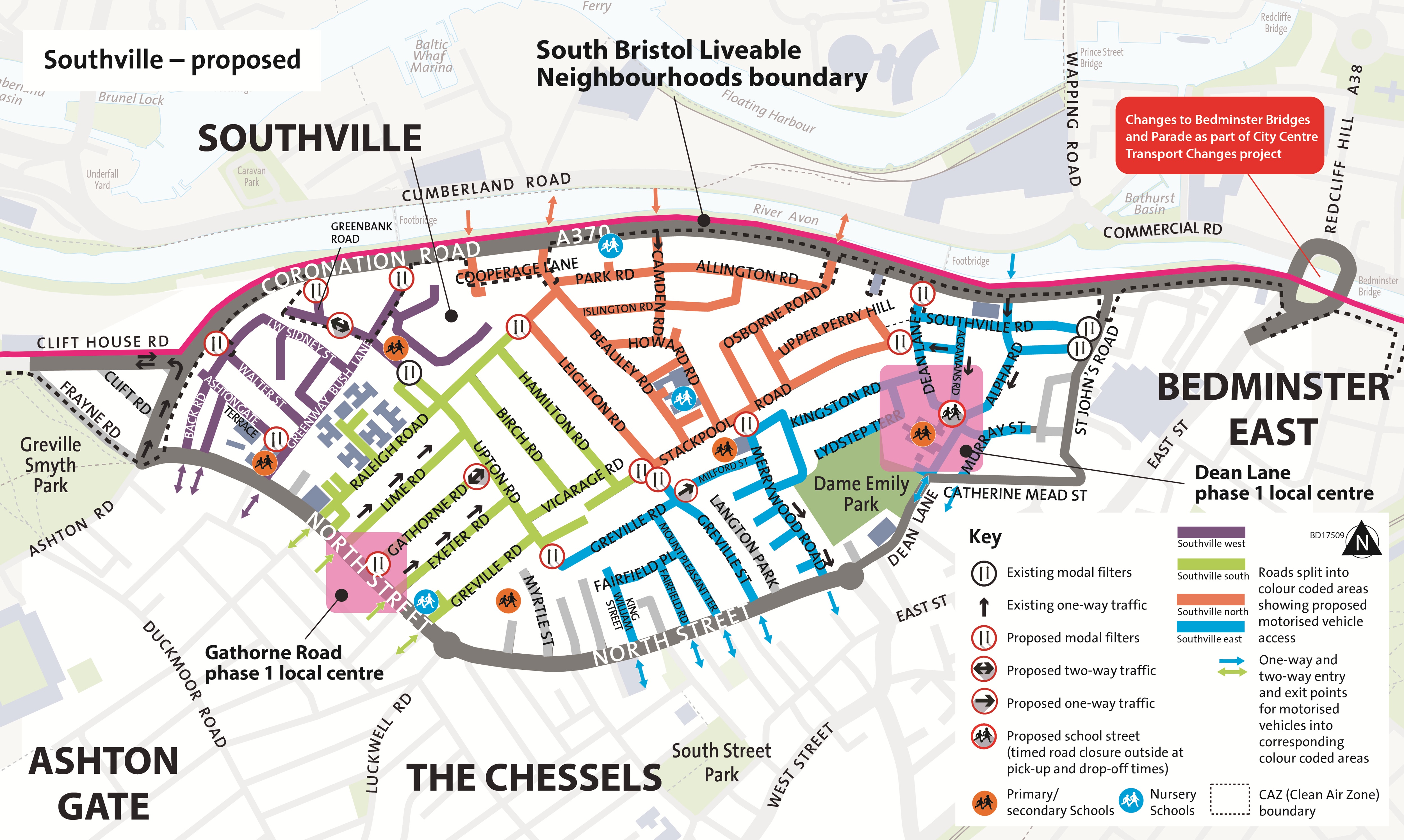
Larger version of proposed traffic layout in Southville map
How the proposed traffic layout would work
We describe below how vehicles would be able to enter and leave and move within each of the four areas in the Southville neighbourhood.
Southville north (orange area)
To access any streets in the orange area, motorised vehicles would be able to enter via Beauley Road, Camden Road or Osborne Road. Access to Cooperage Lane remains unchanged.
Once within the area, motorised vehicles would be able to access any property as usual.
To leave the area, motorised vehicles would need to exit via Beauley Road or Osborne Road.
Motorised vehicle access into and out of the area would be through the Clean Air Zone. If you have a non-compliant vehicle and live or work in the Southville neighbourhood please contact liveableneighbourhoods@bristol.gov.uk to discuss options and support.
Southville east (blue area)
To access any streets in the blue area, motorised vehicles could enter via King William Terrace, Fairfield Road, Mount Pleasant Terrace, Greville Street, Dean Lane, Murray Street or Alpha Road.
Once within the area, motorised vehicles would be able to access any property as usual. Please note the proposals include reversing the existing one-way on Milford Street.
To leave the area, motorised vehicles would need to exit via King William Terrace, Fairfield Road, Mount Pleasant Terrace, Greville Street, Merrywood Road, Dean Lane or Murray Street.
Southville south (green area)
To access any streets in the green area, motorised vehicles would be able to enter via Raleigh Road, Lime Road, Exeter Road or Greville Road.
Once within the area, motorised vehicles would be able to access any property as usual.
To leave the area, motorised vehicles would need to exit via Raleigh Road or Greville Road.
Southville west (purple area)
To access any streets in the purple area, motorised vehicles would be able to enter or leave via Ashton Gate Terrace or Greenway Bush Lane, which would remain two-way. Access to Back Road would be unchanged.
Once within the area, motorised vehicles would be able to access any property as usual with one exception. This would affect properties on Ashton Gate Road and Ashton Gate Terrace, whose access would be affected by a proposed modal filter outside Ashton Gate Primary (Infants). We describe this further in the next section.
Measures to improve community spaces
We also plan to provide the following measures to improve community spaces:
- new cycle parking
- trees and greening
- parklets
- EV charging (this would be in lampposts)
- e-bike/e-scooter parking
We are yet to decide on the exact locations for the measures to improve community spaces. We will need to undertake surveys of underground gas, water, telecoms etc. because this can affect when we can site these things. We will keep you informed about proposals for specific locations for these measures.
Schools and local centres
Road safety improvements are also planned around all school sites and local centres within the Southville neighbourhood.
At this stage we've developed proposals for Ashton Gate Primary (Infants' site) and Gathorne Road and we describe these here. Further work is needed to develop proposals for the streets around other schools and local centres in Southville neighbourhood.
Ashton Gate School
We propose modal filters to close the road outside Ashton Gate School on Ashton Gate Terrace, from the junction with Greenway Bush Lane up to the first row of housing. This would create a safer, calmer entry to the school and allow school children to access their play and sports area more safely. Vehicles travelling from Ashton Gate Terrace to Greenway Bush Lane would need to exit onto North Street and re-enter Greenway Bush Lane.
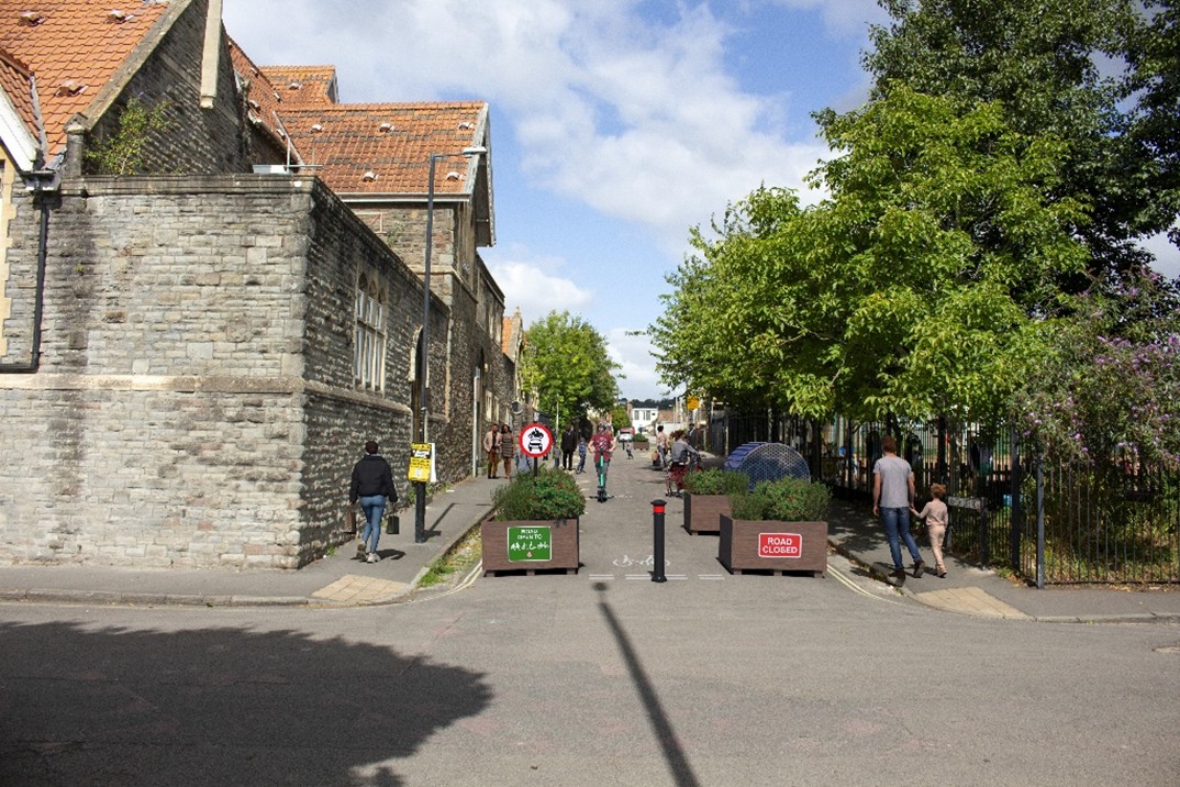
Proposals for Ashton Gate School
Gathorne Road
Following feedback from the community, we propose to close the end of Gathorne Road to traffic at the North Street junction using modal filters. This would:
- make it easier to cross the road
- create spill out space for hospitality
- release space for greenery and arts and culture programming
Gathorne Road would be made two-way and double yellow lines would be installed to create a turning space for vehicles to turn around.
The image below shows the changes to the street we could make using temporary materials. We propose that planters are used to close the North Street end of Gathorne Road. This would allow the closed section to be used for café style seating. Cycling and wheeling would be possible through the closed section. This can be completed quickly and at low cost.
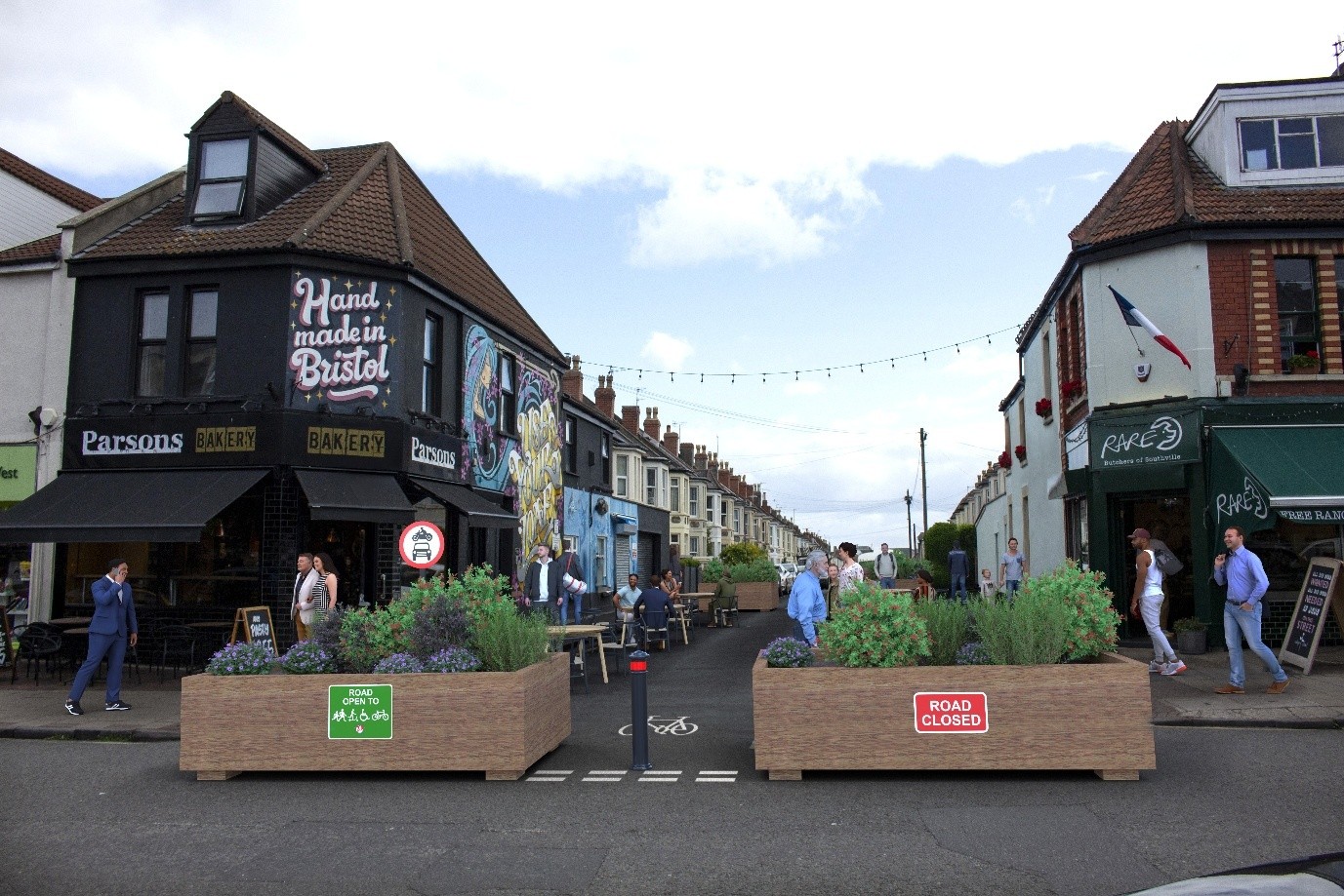
Proposals for Gathorne Road showing initial changes with temporary materials
The next stage would involve a more permanent change using high quality materials and a raised crossing point. The image below shows a recently pedestrianised street off Gloucester Road that is an example of the kind of materials that could be used for a permanent scheme for Gathorne Road.
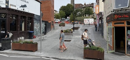
Example of the type of materials that could be used for Gathorne Road
The Bedminster East neighbourhood is the area bordered by Bedminster Parade, Malago Road, Sheene Road, Cannon Street, part of Dean Lane, Catherine Mead Street, St John's Road, and Coronation Road (Figure 35). This is part of the existing Bedminster East Residents' Parking Scheme area. The streets to the west are in the proposed Southville neighbourhood. The streets to the east have improvements planned as part of regeneration projects – we do not describe these here.
The Bedminster East neighbourhood includes the partially pedestrianised East Street high street. Many of the side streets have already been closed or have modal filters to prevent through traffic. The area is a mix of commercial and residential uses. The south of the neighbourhood is also part of the Bedminster Green regeneration area, providing a number of new homes, mixed-use buildings and public spaces.
East Street is often used by motor vehicles ignoring the bus gate, which makes the road less safe for pedestrians and cyclists. The junction of East Street, Cannon Street and British Road is also difficult to cross as a pedestrian or cyclist. Cannon Street has narrow pavements which makes walking more difficult.
In the 2024 engagement you told us that the most important things for this area are:
- priority for pedestrians
- safety for cycling
- personal safety concerns.
You also suggested a number of improvements to address these issues, including:
- protected cycle tracks
- safe crossings and junctions
- modal filters and one-ways to give priority access to walking, cycling and public transport
- wider and clearer pavements
- priority to pedestrians and cyclists at side road junctions
We are proposing 3 types of measures for Bedminster East neighbourhood:
- measures to reduce through-traffic and unsafe speeds
- measures to improve community spaces
- measures around local centres
Measures to reduce through-traffic and unsafe speeds
Because many of the side streets in Bedminster East have already been closed or have modal filters to prevent through traffic, this neighbourhood needs fewer new measures to reduce through-traffic and unsafe speeds.
The long-term vision is to fully pedestrianise East Street and move buses to Dalby Avenue. We also want to create a high-quality cycling route from Bedminster to the city centre through the area – we do not ask you about this here.
As part of Phase 1 of the SBLN project, we propose to improve the gateways at both ends of the pedestrianised section of East Street, at the junctions with Cannon Street and Lombard Street. This would make East Street more accessible by walking, cycling and public transport. These gateways would need further co-design with businesses and the community and could include more space for people on foot, seating, trees and greening, and arts and culture.
An enforcement camera would be installed to enforce the existing bus gate at the junction of East Street with Cannon Street and British Road.
Larger version of proposed traffic layout in Bedminster East map
Proposals for Cannon Street and Lombard Street are described below in the section on local centres in Bedminster East.
In the longer term, we want to make British Road (just outside the Bedminster East neighbourhood) a quiet, safer alternative to West Street for cycling. This could form part of an improved cycling route to the city centre via East Street, Bedminster Parade and new segregated cycle tracks on Bedminster Bridges. The changes to East Street and the junction with Cannon Street and British Road would be an important step in creating this route.
No other changes are proposed to how motorised traffic would access the area.
Measures to improve community spaces
We plan to provide the following measures on residential streets to improve community spaces:
- visitor cycle parking and cycle hangars
- trees and greening
- parklets
- EV charging (this would be in lampposts)
- arts and culture programming
- on-road e-scooter and e-bike parking locations
We are yet to decide on the exact locations for the measures to improve community spaces. We will need to undertake surveys of underground gas, water, telecoms etc. We will keep you informed about proposals for specific locations for these things.
Local centres
Cannon Street
Cannon Street and its junction with East Street and British Road are a key focus for Bedminster East neighbourhood. We propose:
- to reduce the width of the road and widen the pavement on Cannon Street to make walking and wheeling easier
- new traffic signals at the East Street/Cannon Street/British Road junction. The existing signals are old and need replacing. With the new signals, we could provide a safer and convenient crossing for cycles from East Street to Cannon Street and British Road.
Artist's impression of proposals for junction of Cannon Street with East Street
Lombard Street
Lombard Street is a local centre and a gateway at the northern end of the East Street high street. Engagement would take place with the community as we develop more detailed proposals for Lombard Street.
Totterdown has a number of steeply sloping streets and steps. This can be a challenge for people who want to walk, wheel or cycle.
Totterdown's streets are often dominated by vehicles. Walking can be challenging due to narrow and cluttered pavements. There is good access to local shops and public transport on Wells Road, but Totterdown has no bus service at the western side of the neighbourhood.
There are important existing green corridors within the area. These are natural routes like tree-lined paths, parks or green spaces that connect different parts of the neighbourhood. They are great for walking and cycling and allow people to enjoy nature.
Traffic data show high numbers of vehicles from outside the area use streets in Totterdown as a cut through to other places. Commuters also park in this area and then travel on into the city centre. This reduces street space for residents. Busy roads around this neighbourhood can make it more difficult to walk to the nearby primary schools, Victoria Park and the shops on Wells Road.
In the 2024 engagement, you told us that the most important things for Totterdown are:
- priority for pedestrians
- problems with car parking
- safe crossings
You also suggested a number of improvements to address these, including:
- managing on-street car parking
- safe crossings and junctions
- wider and clearer pavements
- modal filters and one-ways to give priority access to walking, cycling and public transport
- managing unsafe vehicle speeds
We are proposing 3 types of measures for Totterdown neighbourhood:
- measures to reduce through-traffic and unsafe speeds
- measures to improve community spaces
- measures around schools and local centres
Measures to reduce through-traffic and unsafe speeds
The existing traffic layout in the Totterdown neighbourhood is shown in the map below.
Existing traffic layout in Totterdown
We propose:
- a bus gate on St Luke's Road to prevent traffic cutting through the area
- a modal filter on William Street between the junctions of Henry Street and Cambridge Street (between The Shakespeare and The Sundial Kitchen)
- to make most of the roads within the Totterdown neighbourhood one-way. This would prevent vehicle stand-offs and reversing
Removing through traffic would reduce the amount and speed of traffic and would make the area safer and more pleasant for walking, wheeling, and cycling. All properties would remain accessible, although routes may change.
We are also proposing a new one-way on Angers Road in the adjacent Totterdown East neighbourhood. This would prevent traffic shortcutting from Bath Road to Wells Road.
Proposed traffic layout in Totterdown
Bus gate on St Luke's Road
We propose a bus gate on St Luke's Road. A bus gate is a short section of road which only buses and authorised vehicles can use. It is a type of modal filter that improves bus journey times and reliability. Charges would apply to vehicles that are not authorised, if they drive through the bus gate. The bus gate would be enforced by a camera. There would not be a physical barrier.
The bus gate would allow access for the planned extended 16 bus route and other essential vehicles such as emergency services. Consideration can also be given to access for Blue Badge holders.
By reducing traffic, the bus gate would make it safer and easier to cross St Luke's Road to walk between Totterdown and Victoria Park. It would also allow for improvements to the Filwood Quietway cycle route connecting into existing and planned cycle routes around Whitehouse Street.
The proposed bus gate would mean businesses in Mead Street would need to be accessed via Bath Road/York Road which is in the Clean Air Zone.
Modal filter on William Street
We propose a modal filter on William Street between the junction with Henry Street and Cambridge Street (between The Shakespeare and The Sundial Kitchen). This would:
- reduce the amount of traffic using William Street as a shortcut
- create spill out space for hospitality
- release space for greenery and arts and culture programming
Traffic priority changes
We propose to make most of the roads within the Totterdown neighbourhood one-way. This would prevent vehicle stand-offs and reversing.
Cycles would be able to continue to use the streets in both directions.
The following streets would be made one-way along their entire length:
- Cheapside Street – from the junction with Oxford Street towards the junction with Henry Street and Stevens Crescent (westbound)
- Green Street – from the junction with Henry Street towards the junction with Pylle Hill Crescent (westbound)
- Hill Street – from the junction with Cambridge Street towards the junction with Pylle Hill Crescent (westbound)
- Pylle Hill Crescent – from the junction with Windsor Terrace towards the junction with Richmond Street (northbound)
- Stevens Crescent – from the junction with Windsor Terrace towards the junction with Cheapside Street and Henry Street (eastbound)
The following streets would be made one-way along part of their length:
Richmond Street
- part of Richmond Street – from the junction with Pylle Hill Crescent to the junction with Cambridge Street (eastbound)
- a short section of Richmond Street from 6 Richmond Street to 1 Richmond Street would remain two-way
William Street
- part of William Street – from the junction with Pylle Hill Crescent to the junction with Henry Street (eastbound)
- a modal filter is proposed on William Street between Henry Street and Cambridge Street (described above)
Windsor Terrace
- part of Windsor Terrace from the junction of Henry Street to the junction with Pylle Hill Crescent (westbound)
Henry Street
- part of Henry Street from the junction with William Street to the junction with Windsor Terrace (southbound)
Oxford Street
- part of Oxford Street - from the junction of Cambridge Street to 106 Oxford Street - at the end of the Tesco car park (southbound)
- a section of Oxford Street west of the junction with St John's Lane (66 to 105) would remain two-way
Cambridge Street
- part of Cambridge Street - from the junction with Richmond Street to the junction with Hill Street (southbound)
- part of Cambridge Street, from the junction with Bellevue Road to the sharp bend on Cambridge Street (southbound). We present two options for this street below
All other streets would remain in their current arrangement.
Options for Cambridge Street
We propose two alternative ways to prevent through traffic using Cambridge Street to cut through to Wells Road. In both options, Bellevue Road would remain open to two-way traffic.
- Option 1 is to make Cambridge Street one-way southbound at the junction of Bellevue Road. This would mean vehicles could access Totterdown neighbourhood from Wells Road but would need to exit via St John's Lane or St Luke's Road. This is shown on the proposed traffic layout map
- Option 2 is to enforce the existing timed restriction with cameras. This is shown on the existing traffic layout map
One-way on Angers Road
We propose the following change to traffic movements in Totterdown East neighbourhood as part of Phase 1. We propose to make a section of Angers Road one-way eastbound, from near the junction with New Walls to the junction with Bath Road. This would prevent traffic cutting through residential streets between Bath Road and Wells Road. Vehicles would still be permitted to turn left onto Bath Road from Angers Road. Vehicles accessing Angers Road would need to do so from Wells Road.
How the proposed traffic layout would work
We describe below how vehicles would be able to enter and leave and move within the Totterdown neighbourhood and the part of Totterdown East affected by the proposed Angers Road one-way.
Totterdown (blue area)
To access streets in the Totterdown neighbourhood (blue area), motor vehicles would be able to enter via the following:
- Windsor Terrace (from St Luke's Road)
- Oxford Street (from St John's Lane)
- Bellevue Road (from Wells Road)
Once within the area, a network of one-way streets would enable vehicles to access all properties. The one-way network would reduce conflicts on narrow streets and reduce the number of vehicles shortcutting through the area.
The modal filter on William Street would mean that vehicles on William Street would have to turn right onto Henry Street.
To leave the area, motor vehicles would be able to exit via:
- Windsor Terrace (to St Luke's Road)
- Oxford Street (to St John's Lane)
- Bellevue Road (to Wells Road) but subject to some restrictions due to the two options for Cambridge Street described above
In both options for Cambridge Street, Bellevue Road would be available as an exit at all times for vehicles travelling from Bellevue Road, Bellevue Terrace, Higham Street or Vernon Street. For traffic from elsewhere in the Totterdown neighbourhood, the 2 options for Cambridge Street would affect use of Bellevue Road as an exit as follows:
- In Option 1, the restrictions would apply to northbound traffic at all times because Cambridge Street would be one-way southbound at its junction with Belleview Road
- In Option 2, the existing restriction on Cambridge Street would apply Monday to Friday 7am to 10am to prevent access from Cambridge Street into Bellevue Road / Wells Road. This would help reduce through traffic in the morning peak and would be enforced by a camera
Angers Road (orange area – part of Totterdown East)
The proposed one-way on Angers Road would prevent vehicles from shortcutting from Bath Road to Wells Road, avoiding the Three Lamps Junction.
All other access would remain unchanged by the Phase 1 proposals.
Measures to improve community spaces
We also plan to provide:
- visitor cycle parking and cycle hangars
- trees and greening
- parklets
- EV lamppost charging
- arts and culture programming
- on-road e-scooter and e-bike parking locations
We are yet to decide on the exact locations for the measures to improve community spaces. We will need to undertake surveys of underground gas, water, telecoms etc. We will keep you informed about proposals for specific locations for these things.
Local centres
Totterdown Square
Totterdown Square is a local centre in this area. We plan to engage the community as we develop detailed proposals to create more community space in Totterdown Square.