
We're starting to plan a liveable neighbourhood in the areas of Southville, Bedminster, Ashton Vale, Malago Vale, Perrets Park, Windmill Hill and Totterdown.
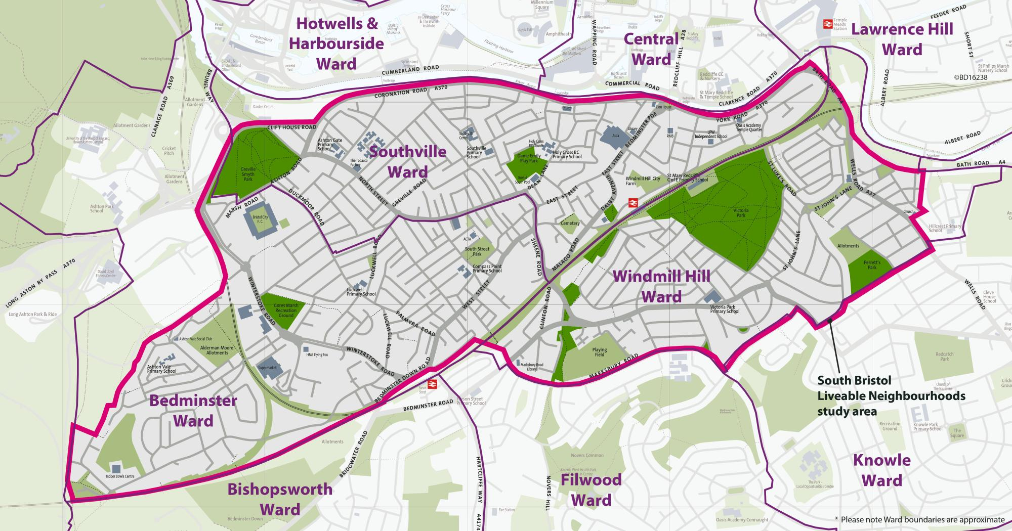
These areas have been chosen because people who live here tell us about the challenges they face with traffic.
We're working with people who live, work, study and travel through these areas to design improvements that will make the streets more people-friendly. Our aim is to design safer and quieter streets to encourage people to walk, cycle and wheel for shorter journeys, improve air quality, enhance the public realm and green spaces, and improve access to local high streets.
We're at the early planning stages of the project. Earlier this year, we started planning by collecting data on traffic, air quality, noise and other information.
Measures that could be installed include:
- modal filters
- bus gates
- pocket parks
- changes to one-way and two-way traffic flow
- cycle hangars
- trees in large planters
- street lighting
- signalised crossings
- footway improvements
- planting street trees (we'll be trialling some trees in large tubs)
- sections of protected cycle track
Driving routes may change, but it will not stop you accessing any of the area by car.
Funding from WECA
Funding was made available from the West of England Combined Authority (WECA) to develop a business case for a liveable neighbourhood.
Community engagement
There have been calls for liveable neighbourhoods in south Bristol from local councillors and people in the community. The project will build upon learnings from the East Bristol pilot.
Near to the city centre
The project area is within a short walking and cycling distance of the city centre, which makes walking, wheeling, cycling and scootering a realistic option for commuting journeys.
Near other major developments
The area is near to and contains major developments, such as Bedminster Green and Temple Quarter. Since 2010, 3,250 new homes have been approved in the planning system within Bedminster, Southville and Windmill Hill. There have been a further 10,000 new homes approved in the immediate surrounding wards. These developments are likely to attract more car journeys, which cannot be accommodated by the transport network.
We need to support and accommodate this future growth as sustainably as possible, while also minimising the impact motorised traffic has on residential neighbourhoods and busy high streets.
Near the Clean Air Zone
The project area is close to the boundary for the Clean Air Zone, which launched in November 2022. Concerns have been raised that additional vehicles may cut through the area to avoid the charges, which will increase the transport issues that have already been reported to us.
Near to walking and cycling routes
Encouraging and enabling more people to use sustainable forms of transport, particularly walking and cycling, helps ease pressure on our public transport and road systems, which are often operating at capacity.
The project area is close to walking and cycling routes, such as the Malago Greenway and Filwood Quietway, which are often very busy at peak times. Improving alternative routes can help alleviate this pressure.
Walking and cycling reduce road danger and improve personal mobility and public health. They're also the 2 cheapest forms of transport and are therefore accessible and inclusive to the broadest range of people in society.
Better for bus reliability
Local bus services can be impacted by congestion when routing through residential streets. Improving bus reliability will help more people to use the bus on a regular basis.
Engagement survey and interactive map:
11 July 2024 to 13 October 2024
South Bristol Liveable Neighbourhoods engagement
pdf South Bristol Liveable Neighbourhood Engagement Executive Summary(1.15 MB)
pdf South Bristol Liveable Neighbourhood Engagement Report(16.35 MB)
pdf South Bristol Liveable Neighbourhood Engagement Report Appendix(1.73 MB)
pdf South Bristol Liveable Neighbourhood Engagement Equalities Appendix(785 KB)
South Bristol Liveable Neighbourhood Engagement Interactive Map Responses
Public online workshops to validate initial findings:
October to November 2024
Consultation:
4 September to 30 October 2025
The consultation stage will help identify areas to trial solutions that can help overcome challenges discussed in the engagement period.
Equalities Impact Assessment
pdf Equality Impact Assessment - South Bristol Liveable Neighbourhoods(2.15 MB)
Co-design:
Some of the proposals will need further input from local residents and businesses to shape the project design.
Statutory consultation:
2026
Detailed designs of the agreed solutions will be made. Issues can be addressed as they arise ahead of the formal consultation.
Inform:
2026
We will keep people informed on the status of the project whilst the legal orders are going through and during construction.
Launch:
2026 to 2027
The project will be launched with the new streets that reflect local wishes.
Other transport and regeneration projects in and around the South Bristol Liveable Neighbourhood project area.
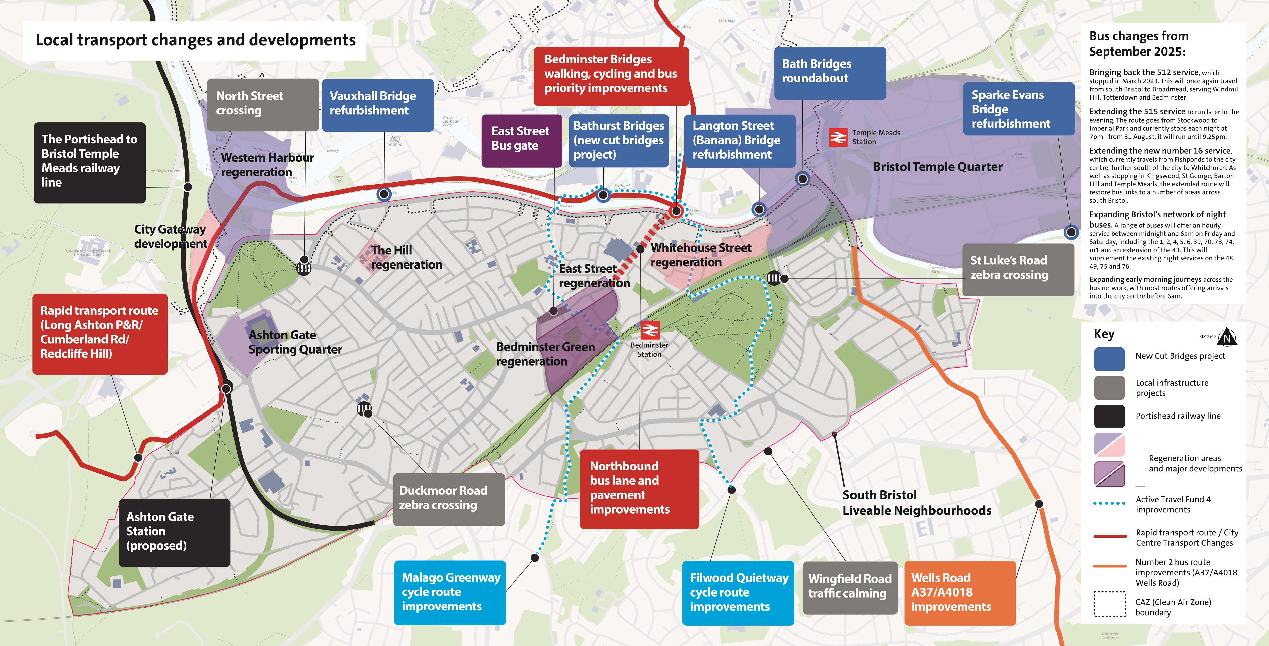
Dean Lane
Improvements to walking, cycling and the general street environment.
Malago Road
Transport improvements and river restoration works in Bedminster Green.
Bedminster Green river restoration and transport consultation
This is part of the Bedminster Green development of 5 sites to bring around 3,500 new residents to the area.
Malago Greenway and Filwood Quietway
Proposed improvements to walking, wheeling and cycling routes in Bristol.
Active Travel Fund 4 Walking and Cycling Schemes
Mead Street Regeneration
Revitalisation of the area around Mead Street, near Bristol Temple Meads.
Mead Street - Bristol Temple Quarter
Whitehouse Street
Regeneration of the area around Whitehouse Street in Bedminster.
Whitehouse Street - East Bedminster Regeneration
Improvements to the number 2 bus route
Improvements to the A37 (Wells Road) bus corridor.
Bristol streets: Transport Corridor Improvements (WEST webiste)
Clean Air Zone
Charging zone for non-compliant vehicles.
St Luke's Road crossing
Community Infrastructure Levy funded zebra crossing.
St Luke's Road - Proposed Zebra Crossing
Duckmoor Road crossing
Community Infrastructure Levy funded zebra crossing
Sparks Evans Bridge, Vauxhall Bridge, Langton St Bridge and Bedminster Bridge Roundabout (twin bridges)
Restoration of bridges that cross the New Cut of the River Avon.